Jordan bid farewell to the mild summer weather..a heat wave expected in the last week of summer (details and recommendations)
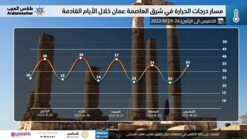
Weather of Arabia - The results of the analysis of the latest weather maps showed that the Kingdom will be gradually affected, starting from Saturday 8/27/2022, by a hot air mass coming from the desert of the Arabian Peninsula that dominates over the Levant, including the Kingdom, and its impact increases and deepens on Sundays and Mondays, causing a stressful heat wave, Amid indications of the continuation of hot weather, varying in intensity from day to day until early September.
Thursday and Friday .. a slight rise in temperatures
Weather forecasters at the "Arab Weather" Center said that temperatures are expected to rise on Thursday and Friday, to become slightly higher than their usual rates for this time of the year, and normal summer weather prevails in most regions, tending to heat with noon and afternoon hours, while it is Hot in the Jordan Valley, Dead Sea, Aqaba and desert areas. At night, it is expected that temperatures will rise compared to the current nights, so that the weather will turn to become generally pleasant to moderate in various regions, with the appearance of some low clouds in the north of the Kingdom, and the winds will be northwesterly moderate in speed.
A heat wave begins on Saturday to affect the Kingdom and intensifies on Sunday
In the details, a hot air mass is expected to gradually rush from the desert of the Arabian Peninsula towards the Levant, including the Kingdom, which will lead to a significant rise in temperatures on Saturday, to become 4-6 degrees Celsius higher than their usual rates for this time of year. The weather is expected to turn hot and dry in general in most areas, and very hot in the Jordan Valley, Dead Sea, Gulf of Aqaba and Badia regions.
Forecasters at the "Arab Weather" Center said that the hot mass will deepen, God willing, on Sunday, so that temperatures will become 7-9 degrees Celsius higher than their average rates for this time of the year, and temperatures will approach around 40 degrees Celsius in many Jordanian villages and cities. Including neighborhoods from the capital, Amman, and the weather is hot to very hot in all regions of the Kingdom, and the winds are light and changing directions, which gives them an additional heat stress.

As for the night, it is also expected that there will be an increase in temperatures compared to the current nights, and a warm weather prevails, tending to moderation during the late night and early morning hours in the high mountainous heights and the eastern plains, with the appearance of some low clouds in some areas.
The scientific reason for the expected heat wave in the Kingdom
It is expected that a heat wave will control the Kingdom’s atmosphere, resulting in a rise in atmospheric pressure in the Arctic Dome, to break the jet streams, become more active and push cold air more than normal towards subtropical regions, similar to opening the refrigerator door, and this is known as negative fluctuation The Arctic (Negative phase of AO), as a result of the distribution of weather systems in the northern half of the Atlantic Ocean, the air rise in the British Isles will direct the path of cold air and push the moderate air masses south towards the central Mediterranean, and this is known as the negative North Ocean Oscillation The Atlantic (Negative phase of NAO), which leads to the intensification of the subtropical atmospheric height and its attraction to the north of the Arabian Peninsula and the Levant, accompanied by a hot air mass.
A "heat wave" is defined as a continuous and continuous rise in temperatures away from their normal rates by 4-6 degrees Celsius for a period of more than 72 hours (three days), and these criteria apply to the Kingdom starting next Saturday, God willing.
Important recommendations about the heat wave that it is recommended to take seriously:
- Avoid exposure to the sun all hours of the day.
- Drink plenty of cold fluids and refreshments throughout the day.
- It is advised not to exert physical exertion outside most of the time.
- Attention not to leave sterilizers and any flammable materials inside the vehicles.
- Attention not to leave children inside vehicles, even for a short period of time.
God knows.
Arabia Weather App
Download the app to receive weather notifications and more..


