Jordan: Details of the areas covered by snowfall forecasts in the Kingdom
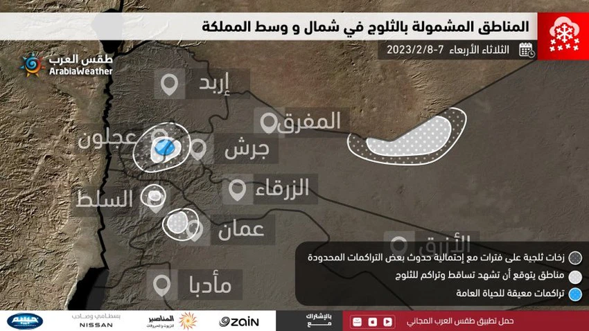
Arab Weather - A short while ago, the weather forecast department at the Arab Weather Center issued a report showing the areas covered by snowfall forecasts on Tuesday and Wednesday, and the report stated that the fourth-degree depression, which is associated with a very cold air mass in all layers of the atmosphere, is deepening Its effect, God willing, with the hours of midnight (Monday / Tuesday), so that the rain will increase, especially in the central regions, including the capital. The report indicated that the areas where snow is expected to begin to fall and accumulate are the high northern mountain heights, which are more than 1,200 meters above sea level, which include the highest mountains of Jerash and Ajloun, in addition to the heights of Mafraq Governorate, i.e. those areas adjacent to Jabal Al-Arab. Snow mixed with rain is also excluded in other high mountain heights in the north and center of the Kingdom, including the high mountain heights in the capital.
Tuesday: Stormy weather, heavy rain and snow in some areas
And in the details, it is expected that the weather on Tuesday 7-2-2023 will be very cold, windy, cloudy, and rain heavily in the north and center of the Kingdom, with heavy showers of hail sometimes, and these precipitations may lead to a large flow of valleys and the formation of torrential rains. And the water level rises. And the report issued by the Arab Weather Center indicated that the cold will be sufficiently penetrating on Tuesday morning inside the Kingdom to cause temporary snowfalls over the high mountain heights that exceed 1,000 meters above sea level in the north and center of the Kingdom, with occasional accumulation (which includes the peaks west of the capital). Amman and the Balqa peaks such as Zai, Umm Joza, the heights of the Sweileh region, Tla’a Al-Ali, Al-Jubaiha, the University of Jordan, Dabouq, Abu Alanda and the surrounding areas), provided that the level of snowfall rises again on Monday afternoon and becomes mixed with rain in these areas while the precipitation continues Snow above heights more than 1100 meters above sea level.

On the contrary, and as a result of the distributions of atmospheric pressure and the movement of clouds, the path of clouds laden with rain and snow on Tuesday will be directed towards the northern and central regions of the Kingdom to a greater extent than is the case in the rest of the regions, which means that the weather will remain on Tuesday in The south and east of the Kingdom, very windy and cold, with occasional dust waves, and random showers of snow are likely to fall over the Al-Sharah Mountains in the south of the Kingdom.
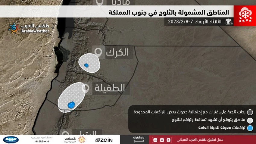
The high elevations of Karak and Tafilah will also receive snow
And the Kingdom continues to be affected on the evening and night of Tuesday/Wednesday by the same depression, which is classified as a fourth degree, so that it is expected that snow will continue to fall at intervals with its accumulation above the peaks of the high mountain elevations, whose height exceeds 1100 meters above sea level, which includes the heights of the mountains of Jerash and Ajloun, in addition to To the heights of the Mafraq Governorate adjacent to Jabal Al-Arab, and extends with the night hours to include the heights of the Southern Mazar District and Mutah in the Karak Governorate, and later to the various heights of the Tafila Governorate. And in the hours after midnight, snowfall extends intermittently to the high mountain heights, which are more than 1000 meters above sea level, with occasional accumulation, which includes the peaks west of the capital, Amman, and the peaks of Al-Balqa.

The depression is moving away from the Kingdom on Wednesday
It is expected that snowfall will be renewed intermittently on the morning of Wednesday 8-2-2023 above the high mountain elevations, which are more than 1000 meters above sea level, with accumulation sometimes, and it is not excluded that some snow showers extend at intervals to below that height, and the amount of accumulation varies Snow, of course, depends on the height above sea level, in addition to the continuity of snowfall.
And the air depression moves away from the Kingdom gradually on Wednesday, and the weather will be very cold and often cloudy in most regions, with showers of rain and hail from time to time in the north and center of the Kingdom in addition to parts of the southern and eastern regions, and it weakens The rain is largely in the afternoon and afternoon of Wednesday, and it recedes from most areas as we enter the evening hours of Wednesday and the night of Wednesday-Thursday. While cold winds are expected to flow towards the Kingdom without atmospheric activity, as minimum temperatures fall to around zero degrees Celsius in many regions, with cold weather prevailing, and quantities of clouds appear at different altitudes, which reduces the chances of frost and freezing except in Southern high mountain peaks (Sharah).
Find out the altitude of your area
And by clicking here, you can find out the height of your areas above sea level.

God knows.
Arabia Weather App
Download the app to receive weather notifications and more..


