Jordan: Temperatures will continue to be warmer than their usual levels in the coming days and an expected change in the weather system starting in the middle of the month is believed to lead to improved rain chances.
Arabia Weather - The outputs of computer simulations of the movement of air masses and systems at the Regional Arabia Weather Center indicate expectations that the regions of the eastern European continent and western Russia will continue to be affected by a solid air pressure that works to interrupt the direction of the relatively cold and humid air masses to the eastern basin of the Mediterranean Sea, as this is considered The region extending from western Russia in the north to Turkey in the south is the main feeder, God willing, for the formation of weather conditions in the eastern basin of the Mediterranean Sea, at the expense of large parts of northern, western and central Europe being exposed to air depressions.
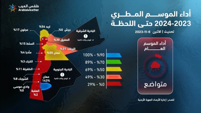
As we enter the second week of November of this year (2023), the Jordanian Meteorological Department data showed that the percentage of what has been achieved in the season so far amounted to only 1%, while the same data indicated that the performance of the rainy season It did not exceed 25% compared to the amounts of rain that are supposed to fall for this time of the year, as this percentage is supposed to exceed 90% in normal conditions in many areas. In addition, temperatures are still recording several degrees higher than their usual levels since the beginning of this month, and have even approached 30 degrees Celsius in the east of the capital on some days, and it is expected that these conditions, which can be described as warm, will continue during the coming days.

The specialists at the Arabia Weather Center believe that there are indications of a change in weather patterns by the middle of November, which is believed to lead to the behavior of the weather patterns returning to the usual autumn behavior and thus, in theory, increasing the chances of weather conditions occurring in the Levant, including The kingdom. Computer modeling for medium and long-term forecasts has recently begun to sense an increase in the chances of a relatively cold air mass rushing into the region during the third and fourth weeks of this month, with the possibility of the emergence of cases of air instability, and perhaps the Kingdom may be affected by the first air depression of this season with a decrease in There is a significant and noticeable increase in temperature compared to what is the case these days, and thus the weather becomes autumnal and the need for warmer clothes increases and perhaps the use of heating methods at night in many areas, especially the high mountain highlands.
Below are the details of the forecasts, taken from the monthly bulletin previously issued by the Arabia Weather Center for the next four weeks, God willing:
Week 2 (November 8-14)
- Rainfall: Below average.
- Temperatures: higher than average.
- Chance of floods: Details are available through the special package on the Arab Weather website and application from here
- Description of the weather systems: All regions of the Levant and Jordan remain under an air mass with temperatures warmer than their usual levels, so that the weather is generally moderate in temperature during the day, but tends to be cold at night. By the end of the period, it is expected that the weather systems will begin to change.. Details are available through the special package on the Arab Weather website and application from here.
Week 3 (November 15-21)
- Rainfall: About average.
- Temperatures: About averages.
- Chance of floods: Details are available through the special package on the Arab Weather website and application from here
- Description of the weather systems: It is expected that a change will occur in the weather system such that the Kingdom may be affected at the beginning of this period by a weather condition that may be in the form of a state of air instability that raises the chance of... Details are available through the special package on the Arab Weather website and application from here.
The fourth week and the rest of the month (November 22-30)
- Rainfall: About average.
- Temperatures: Shift below average.
- Chance of floods: Details are available through the special package on the Arab Weather website and application from here
- Description of the weather systems: This week is characterized by clear weather fluctuations in the atmosphere... Details are available through the special package on the Arab Weather website and application from here.
We ask God to give us rain and not make us despondent
Arabia Weather App
Download the app to receive weather notifications and more..


