Latest developments | Monitoring the development of the first tropical storm in the Bay of Bengal with an Arabic name proposed by Yemen (Sand), threatening India and Bangladesh with torrential rains and strong winds.
Arabia Weather - Weather forecasters at the Arab Regional Weather Center said, after following up on the latest data received from remote sensing systems and weather observatories, that the first tropical storm has developed in the Bay of Bengal for this year, carrying extremely huge amounts of rain that threaten to raise the risk of flash floods and landslides threatening northwest India and Bangladesh. It is likely that the storm will bear an Arabic name chosen from Yemen (sand) within the naming table for tropical conditions prepared in advance.
Sensing: Dense bands of cumulonimbus thunderclouds orbit around the center of the tropical storm in the Bay of Bengal, and effects will be more noticeable tonight.
Satellite images (remote sensing) developed within the Arabia Weather Center monitor the presence of very dense bands of strong cumulus clouds with vertical growth to high levels in the atmosphere revolving around the center of the storm. It is expected, according to the latest computer simulation outputs, that the storm will continue its movement very slowly towards the north and thus Its effects will have clearly begun on northwest India and Bangladesh, in addition to indirect effects on Burma. As the storm’s impact focuses on India and Bangladesh, bundles of cumulonimbus thunderstorm clouds with very heavy rain will blow with strong winds that will disturb the waves in the depths and near the coast.
Advanced computer modeling senses that the storm will intensify on Sunday and Monday and hit India and Bangladesh with full force
Specialists at the Arabia Weather Center said that the latest outputs of computer simulation models indicate an intensification of the storm (sand) on Sunday, especially in the evening and at night, and will continue on Monday when it reaches the coasts of northwestern India and Bangladesh, where atmospheric pressure values deepen, and thus the winds intensify and thunderstorms gain more strength. Due to the increase in its nourishment with latent thermal energy and humidity, the effects of the storm were then clearly evident with very heavy rains accompanied by strong thunderstorms and strong winds of up to 90 km with strong gusts of up to 133 km/hour.
Due to the strong winds, the level of waves is expected to rise to about 7 meters during the peak period, threatening coastal cities with floods, in addition to the occurrence of huge amounts of rain ranging between 400-700 mm that vary from region to region depending on the terrain, with a high risk of torrential torrents, flash floods, and perhaps the occurrence of landslides. And rocky.
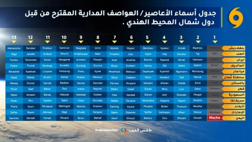
The tropical state acquires an Arabic name, so how are the tropical states named and what is the purpose of that?
The tropical state in the Bay of Bengal acquires the name (sand), which is an Arabic name of Yemeni origin. The tropical states that form in the northern Indian Ocean, including the Bay of Bengal, are named by the Specialized Regional Meteorological Center, headquartered in New Delhi - India, on behalf of the member countries of the international organization. For Meteorology for Asia and the Pacific, 65 Arab names were registered on the list proposed by the group of Arab countries in the committee, namely: the Sultanate of Oman, Saudi Arabia, Qatar, the Emirates, and Yemen.
To name tropical storms in the northern Indian Ocean, the Sea of Oman, or the Bay of Bengal, the name in the table of names previously placed on the list is used by the committee in descending order from top to bottom. Each member of this committee is tasked with choosing a name for a storm, provided that the name is easy. The pronunciation must not have any political, religious, ethnic, or racial meaning, use, or projection. The full names are then presented to the committee for consideration and approval, to be placed on the list ready for use in order.

The practice of naming tropical storms and cyclones began many years ago to aid in quick identification of storms in warning messages, on the assumption that names are much easier to remember than numbers and technical terms. Many believe that naming storms makes it easier to report tropical cyclones in the media, and raises the level of interest in warnings. It enhances the preparedness of local communities.
God knows.
Arabia Weather App
Download the app to receive weather notifications and more..


