Latest updates: The area of the eye of Hurricane Beryl is extremely large and is larger than the area of 4 Arab countries. Details

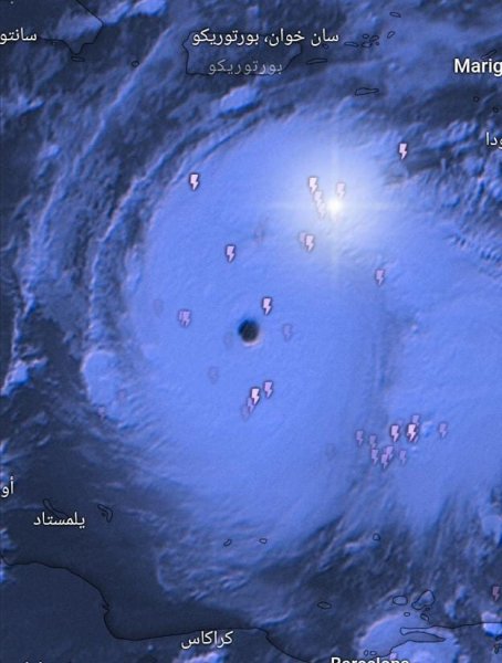
Arabia Weather - Satellite images at the Arabia Weather Center monitor the eye of Hurricane Beryl, which may appear somewhat small from satellite images, but through remote measurement systems, the area of the eye of the hurricane reaches a very large area, which means that its area is larger than the area of 4 Arab countries.
The geographic area of the eye of the hurricane is larger than Kuwait, Qatar, Bahrain, and Lebanon
The area and geographical extent of the eye of the hurricane is about 31,000 square kilometers and 300 metres, which means that its area has exceeded the area of Qatar, Bahrain, Kuwait, and Lebanon.
It is scientifically and meteorologically known that the eye of a hurricane is an area where air collects and clouds build around the eye, which means that the eye is an area of very low air pressure that builds its wall violently but is completely stable and calm. The crossing of the eye usually deceives residents with the stability of the weather and the appearance of sunshine, thinking that the hurricane has departed, but The hurricane's most violent eye wall soon crosses and destroys everything in its path with torrential rains and strong winds.
Follow the hurricane's movement through satellite images from here
After monitoring the latest computer modeling data at the Arabia Weather Center, it is expected that the hurricane will continue to move westward into the waters of the Caribbean Sea to hit the Caribbean islands strongly before retreating on Thursday and Friday when it reaches Mexico and Guatelama, but it also threatens with floods and landslides. The path and intensity forecasts can be stated in the following points according to For the latest updates, which can be updated according to developments that may occur in the hurricane:
Tuesday : The huge hurricane continues within the fifth category and moves westward, affecting various Caribbean islands with its strong winds, torrential rains, and rough waves.
Wednesday : The hurricane continues to move westward into the waters of the Caribbean Sea, but its classification has decreased to become a third category according to international standards, which is an advanced degree and of high danger. It will hit the Dominican Republic and Haiti with rain, winds, and waves, threatening floods and submerging the coastal areas with waves. Watch the rest of the days with details from here. .
God knows.


Arabia Weather App
Download the app to receive weather notifications and more..