Libya | A subtropical storm in the middle of the Mediterranean and expectations of its movement to the northeastern coasts in the coming days
Arab Weather - The weather forecast staff at the Arab Regional Weather Center is monitoring the latest observations of satellite images that indicate the development of a subtropical Mediterranean storm in the middle of the Mediterranean Sea affecting the Italian island of Sicily, where satellite images monitor thick rainy clouds revolving around the center of the storm.
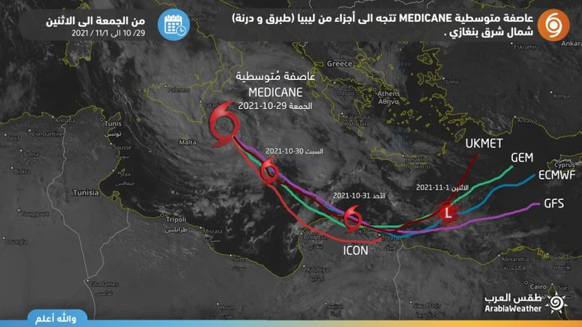
Updates of various numerical models indicate that the storm is moving towards the northeastern coast of Libya
The weather forecast staff at the Arab Weather Center is closely monitoring updates of numerical weather models regarding the expected path of the Mediterranean storm in the coming days, as most updates of numerical weather models from global centers (Gfs, Ecmwf, Icon, Gem and others) indicate that the Mediterranean storm will start moving towards Southeast gradual from Saturday.
With the movement of that air system in this direction, it is expected to hit the northeastern coasts of Libya from Sunday morning and during the rest of the day. Its effects mainly include Derna and Tobruk (northeast of Benghazi), bringing with it active winds, with gusts touching 40 knots, causing high waves. For more than 4 meters on the beaches, coinciding with heavy to heavy rain, it warns of strong wind speed and the risk of torrential rain and high waves on the beaches.
According to the outputs of the numerical air models, the air system is moving on Monday to a north-eastern direction as it retreats to an air depression.
The rise in the surface temperature of the Mediterranean waters contributes to the development of this weather system, as sea water surface temperatures range between 22 degrees Celsius or more in some areas, and the Arab Weather website advises to follow the updates issued in the coming days.
For more details and developments in the weather, download the Arab Weather app from here
God knows.


Arabia Weather App
Download the app to receive weather notifications and more..