Major consequences of polar vortex split, resulting in a cold wave that brings temperatures to -50 degrees Celsius in the United States
Arab Weather - The latest readings from the so-called computer simulation indicate that there will be consequences for the expected division in the polar vortex, which will produce extremely extreme weather patterns in some areas of the world, especially the United States of America and eastern Europe, in the coming days.
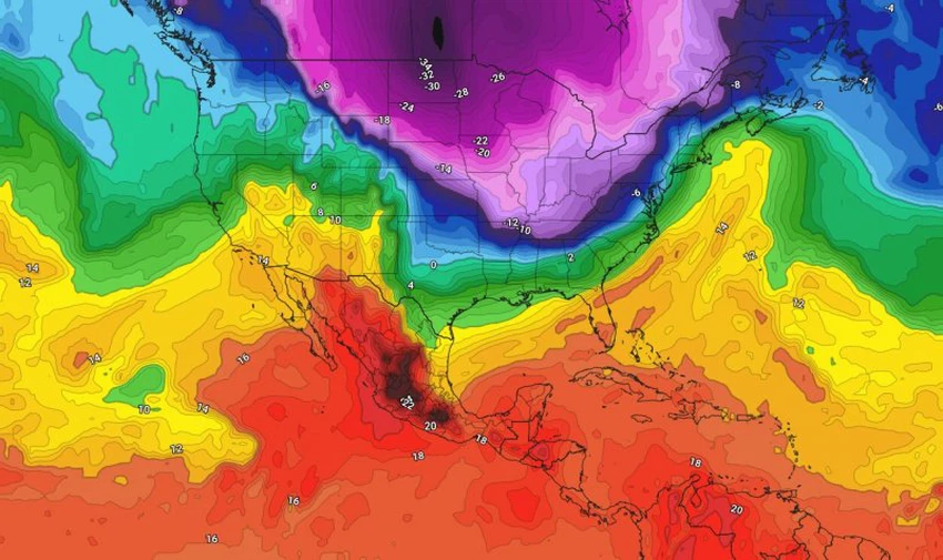
Polar Vortex Split Impacts US, Eastern Europe
The polar vortex is rushing towards North America, including Canada and Greenland, in the form of a very cold and large air mass coming directly from the North Pole towards the North American continent and the mentioned areas, causing very cold winter weather, as temperatures in some areas drop to about 40-50 degrees Celsius below zero, which means a severe wave of severe cold, with widespread snowfall in several states, especially the northeastern states, and the occurrence of a severe state of freezing in large areas.
At the same time, large areas of Western Europe remain under the influence of a strong high pressure system in all layers of the atmosphere, and temperatures are warmer than average for this time of year, while the eastern parts will be under the influence of a very cold air mass in the coming days, bringing with them very low temperatures.
How is the strength of the polar vortex measured and what does strong winds in the polar vortex mean?
The strength of the Arctic vortex is determined by several key factors, and its strength is usually measured by the strength of the winds within and around it. This is done by measuring the speeds of zonal winds (moving from west to east) around the Arctic Circle at 60 degrees latitude. One of the most important factors affecting the strength of the polar vortex is the "polar jet stream," a stream of fast winds that forms at high altitudes and surrounds the vortex.
When winds in the jet stream are strong, they strengthen the polar vortex, which helps trap cold air within the polar region. In this case, the vortex remains stationary and stable, which means cold weather stays confined to northern regions. But when the jet stream weakens, the vortex becomes distorted, allowing cold air to rush south toward warmer regions, causing temperatures to drop in parts of Europe, North America and Asia.
Scientists measure the strength of the polar vortex using an index called the Arctic Oscillation (AO), a numerical indicator that helps describe atmospheric pressure and weather patterns over the North Pole. When the AO is in its positive phase, the polar vortex is strong and cohesive, keeping cold air trapped in the north. When it is in its negative phase, the vortex is weaker, allowing cold air to rush south.
And God knows best.


Arabia Weather App
Download the app to receive weather notifications and more..