Rainy weather affects 9 Arab countries with varying severity from one country to another
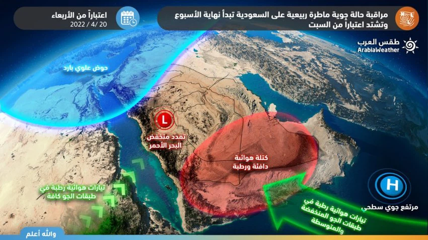
Weather of Arabia - Parts of the Arabian Peninsula region, including Saudi Arabia, will enter a period of air activity from Thursday 4/21/2022 until at least the end of the holy month. Forecasters at the Arab Weather Center for Meteorology and Forecasting say that the region is on a date with a large-scale rainy weather that includes many Arab countries during the coming days. It is considered the best this spring in terms of the area of the affected areas and the abundance of clouds accompanying them, after God’s will.
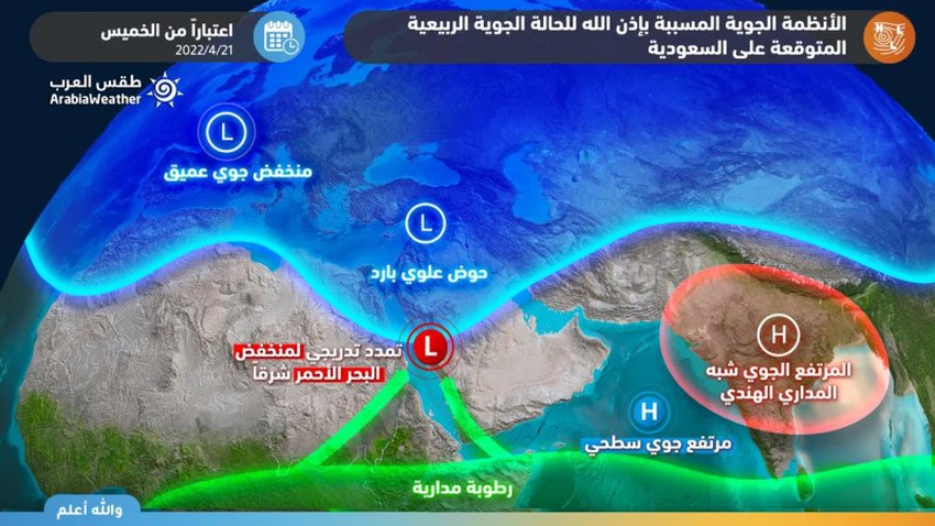
These expected weather disturbances on a regional scale come as a result of a low air rush in the high air layers towards the eastern Mediterranean and northern Egypt, in conjunction with the blowing of warm and humid air currents from tropical shows, which leads to the emergence of unstable weather conditions and a clear surface response to the Red Sea depression. And it is effective in Saudi Arabia in particular, during the coming days, and with the cold upper basin moving towards the east early next week, the rain area spreads/widens and includes large parts of Iraq and Kuwait, and to a lesser extent Bahrain, Qatar and the Jordan Valley. While the impact of the depression is limited to the Sultanate of Oman and the Emirates in the form of local formations on the Hajar Mountains and the eastern mountains of the country, God willing.

Heavy rain expected
Large parts of Saudi Arabia will be affected by the rainy situation
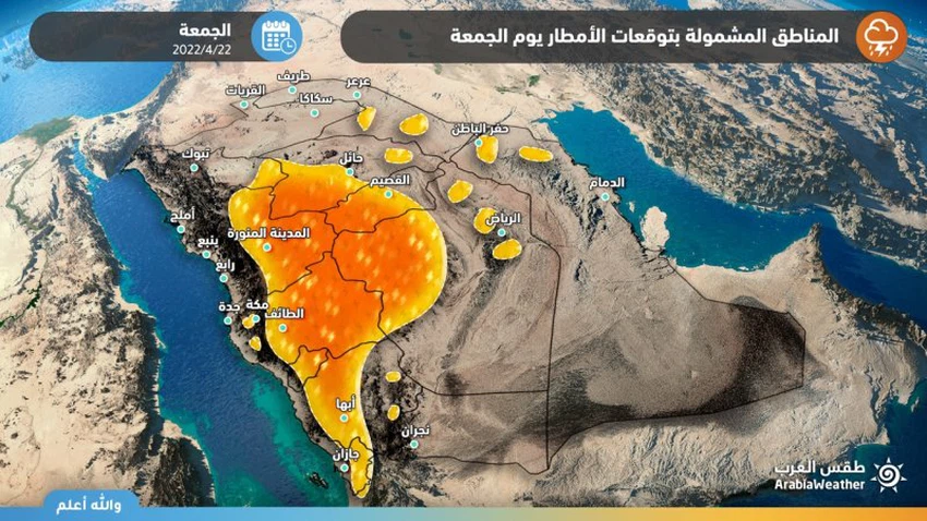
The latest analyzed and received information and data show that the impact of the rainy situation will have a wide impact on the Kingdom of Saudi Arabia, as the rains on Thursday and Friday include the heights of Jazan, Asir, Al Baha, Makkah, Madinah and its eastern slopes, in addition to random parts of the administratively Riyadh, Hail and Qassim regions, with an opportunity to extend some rainy clouds. For the northern sector of the Kingdom, these rains are of varying intensity, and sometimes heavy with hail and surface wind activity during thunderstorms, with the possibility of water gatherings, God willing.

The weather maps, after God’s will, herald an expected spread of rain opportunities on Saturday and Sunday, April 23 and 24, 2022, to extend to large parts of the northern and eastern sectors of the Kingdom, while continuing in the rest of the regions, as a result of the deepening of the cold upper basin of the Kingdom’s atmosphere, to increase the thermal differences between the warm air The proximity of the Earth's surface heated by solar radiation and the cold air above, along with warm and humid air currents blowing from tropical shows. This system works to raise the strength of rain and intensify the intensity of thunder clouds on the mountainous heights and eastern slopes located in the west of the Kingdom, and the extension of rain clouds to include large parts of the Kingdom, and the chances of rain are improving in the capital, Riyadh in particular, starting from Sunday evening, God willing.
The upper cold basin moves east on Sunday and Monday
And rain extends to Kuwait and Iraq, starting from the beginning of next week
According to the numerical simulation indicators of the atmosphere , the depression in the upper atmosphere will move eastward on Sunday 04/24-2022 and center over Iraqi lands, to create unstable weather conditions over large parts of central and southern Iraq, including the capital, Iraq, and it is not excluded that it will extend Some rain clouds, especially with the evening and night hours, to include parts of Kuwait. The depression will deepen on Monday, God willing, to intensify the unstable weather over large parts of Iraq and Kuwait, and thunder showers are accompanied by rain, God willing, and they will be of varying intensity overall with the presence of heavy intensity in some areas, coinciding with the activity of winds at intervals, and these rains are accompanied by precipitation Cold showers and gusty winds. The chances of rain will continue to vary greatly for the rest of the week, God willing.
It is accompanied by rains of varying intensity
Rain clouds extend to Qatar and Bahrain in the middle of next week
According to Arab weather analyzes, it is expected that as the upper cold basin moves eastward, weather fluctuations will intensify in the east of the Arabian Peninsula in the middle of next week, and as a result, the chances of rain will improve on Qatar and Bahrain, so that cumulus clouds multiply and rain showers of varying intensity, with the presence of heavy foci Sometimes. These rains are accompanied, God willing, by the occurrence of lightning and thunder, and the activity of surface winds.

The rain is concentrated on the mountainous heights
Details of the impact of the rain situation on the UAE and Oman
The Hajar Mountains and the neighboring areas and the eastern mountains of the UAE are increasingly affected during the afternoon and afternoon hours on Fridays and Saturdays in particular by unstable weather conditions, so that the area of cumulus formations expands, with an opportunity for these clouds to extend to some coastal areas overlooking the Sea of Oman, God willing. Cumulonimbus with precipitation of varying intensity accompanied by thunder and the activity of downward winds at times.
Thunder rain sometimes
Monitoring the expansion of rain in Yemen in the middle of the week
It is expected, God willing, that the chances of cumulus clouds will focus on the western highlands of Yemen during the coming days, and the clouds will be accompanied by heavy rain at times and thunderstorms. regions, and the formation of water bodies or torrents is not excluded. Given the remoteness of the time period, it is recommended to follow up on the reports issued on a daily basis, as the details will be listed steadily, God willing.
Read also:
Details of the depth of the Red Sea depression over Jordan
All of the above is within the context of the latest forecasts of the weather readings issued by the Arab Regional Center for Meteorology and Forecasting, so updates will be released that will highlight more details incrementally whenever needed, God willing.
Arabia Weather App
Download the app to receive weather notifications and more..


