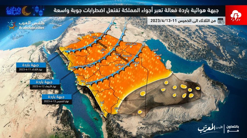
Saudi Arabia: A `highly effective` cold front crosses the Kingdom's airspace, accompanied by more severe weather disturbances in the coming days
Arab Weather - The latest weather readings in the Arab Weather Center indicate expectations of an intensification of rainy activity in large parts of the Kingdom of Saudi Arabia in the coming days, as a result of the crossing of a cold air front. And the same readings indicate that this front is accompanied by thick cumulus clouds, which means that there is a high chance of severe downward winds that lead to temporary sandstorms, in addition to the occurrence of lightning and thunderbolts, and these clouds also cause heavy rains in some places. areas leading to runoff of valleys and reefs, in addition to the rise in water levels.
Tuesday: The cold air front begins to cross the north of the Kingdom, with rains of varying intensity in several parts of it, and gradually extends to some central regions.
It is expected, God willing, that quantities of cumulus clouds will multiply during the day on Tuesday, starting from the Tabuk and Al-Jawf regions, and the Turaif Governorate, and it will be accompanied by moderate rains, interspersed with heavy spots at times.
Cumulonimbus clouds gradually intensify in the afternoon and evening hours and extend to Hail and the rest of the northern border governorates, in addition to parts of the east and north of the Medina region, and the rains are of varying intensity and are accompanied by the occurrence of thunderstorms sometimes, showers of hail and activity in the exciting downward winds. for dirt and dust.
And later during the night, it is possible that some rain clouds will extend to Al-Qassim, Hafar Al-Batin, and the north of the Riyadh region administratively, and they will be accompanied by moderate rains in their entirety.
While the weather is relatively hot in the rest of the Kingdom, and the southwest winds are active in several parts of the central and eastern regions, causing dust and dust.
The rainy weather activity intensified on Wednesday, and moderate to heavy rains are expected in several parts of the northern borders, Qassim, Hail and Medina, and gradually extends to other areas, with an alert of the possibility of runoff of valleys and reefs
And it is expected that the cold air front will gradually affect during the day on Wednesday large parts of Hail, Qassim, Medina and Hafar Al-Batin in addition to the eastern governorates of the northern border (Rafha). Heavy hail at times, and the winds are active at the front of the cold front and cause temporary dust storms to form.
While the weather is completely different in the rest of the central regions (including the capital, Riyadh) and the east, so that the southwest winds are active and the temperatures rise, and the weather is dusty in several regions.

And as the cold front continues to advance in the evening and night hours, cumulus rain clouds extend to large parts of the Riyadh region administratively, including the capital and the eastern region, and are accompanied by medium rains that may be interspersed with heavy spots at times and are accompanied by the occurrence of thunderstorms at times.
In addition, a significant decrease in temperatures occurs in large parts of the north and northwest of the Kingdom, up to the north of the central region.
Thursday: The weather activity weakens, with chances of rain continuing in separate parts of the eastern and central regions
And the weather activity clearly weakens on Thursday, but the opportunity remains ripe for thunderstorms of rain to fall on parts of the Eastern Province, especially the northern parts of the region, as well as separate parts of the Riyadh region administratively and some southwestern highlands.
And the drop in temperatures extends to the central regions, including the capital, Riyadh, so that temperatures are much cooler than their usual rates in the northern borders, Tabuk, Al-Jawf, Hail, Qassim, Medina, the north of the eastern region, and the administrative region of Riyadh, so that the minimum temperature drops to ( 6-10) degrees Celsius north latitude.
God knows.
Arabia Weather App
Download the app to receive weather notifications and more..


