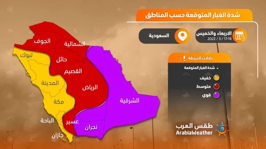
Saudi Arabia | Arab Weather issues a report showing the areas most affected by dust waves and sandstorms expected at the end of this week
Arab Weather - The forecast staff in the Arab weather expected that large parts of Saudi Arabia would be affected this weekend by dust waves and sandstorms, which are considered the strongest, most extensive and influential since the beginning of the season.
This sandstorm will result from the daily impact of the eastern basin of the Mediterranean and the Levant region with a very cold air mass, in conjunction with the concentration of a shallow air depression in the south of the Arabian Peninsula, which leads to the payment of active northerly to northeasterly winds to strong speed, which raise dust and possibly It is working to form sandstorms, and it is expected that the eastern and southern Riyadh administratively, Najran and Asir will be the most affected by the consequences of the expected dust waves.
Decreased and possibly lack of horizontal visibility in some areas
The areas most affected by sandstorms are expected Wednesday and Thursday
In the details, a cold air front of polar origin, but dry, is rushing towards the Kingdom with a significant decrease in temperatures, and as a result of the thermal differences and the corresponding significant decline in the values of atmospheric pressure, the northeastern winds are active on Wednesday, raising dust and dust in different parts, with the possibility of Dust waves form in parts of eastern, central and southern parts of the Kingdom.

On Thursday, the cold air mass of polar origins deepens, so that the wind speed increases and is accompanied by severe gusts sometimes in parts of the center, east and south of the Kingdom, especially in parts of the Eastern and Riyadh regions administratively. Horizontal visibility and may be absent in some areas.
These weather conditions require attention from:
- The danger of strong winds that may reach the 70 km/h barrier.
- The risk of a decrease in the range of horizontal visibility due to dust and dust stirred up.
- Risk of complications in patients with respiratory system and eyes due to dust.
Arabia Weather App
Download the app to receive weather notifications and more..


