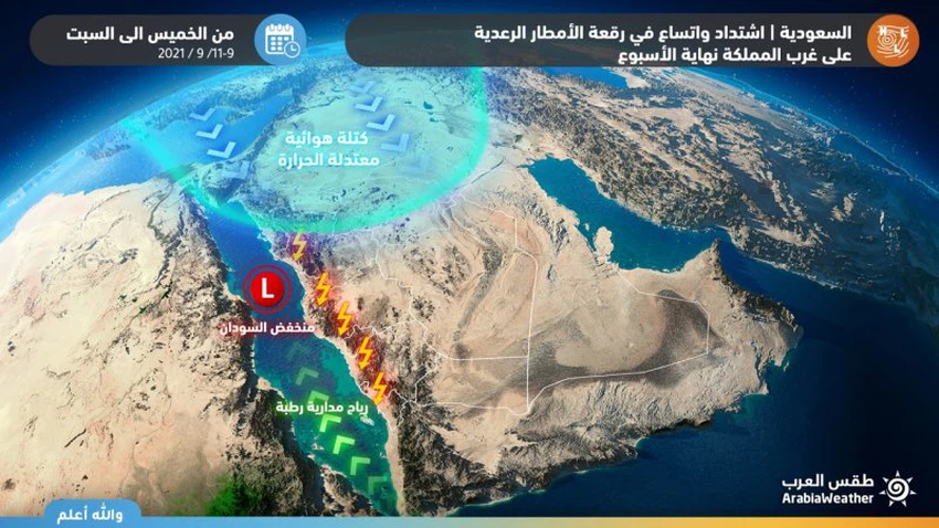
Saudi Arabia | Intensification and expansion of thunderstorms in the west of the Kingdom during the weekend
Arab weather - the latest updates treated internally in Arab weather indicate an air mass with temperatures below their normal rates in the north of the Arabian Peninsula, working on a significant decrease in temperatures in the northern part of the Arabian Peninsula on Friday, while the decrease is more pronounced on Saturday, Simultaneously with that, cumulus thunderclouds are expanding over parts of the western part of the Kingdom, God willing, and here are the details:
Areas covered by rain forecast on Friday and Saturday
Intensification and expansion of rain in parts of the west of the Kingdom
In the details, it is expected that the convective daily and seasonal thunderstorms will multiply again on the western and southwestern highlands of the Kingdom during the weekend, to include the highlands of Jizan, Asir and Al-Baha.

It is expected that the formation of cumulus thunderstorms will expand, especially on Saturday, to include new areas, such as Makkah and Taif, especially the southern parts of them, so that cumulus thunderstorms will multiply at intervals , and the opportunity will gradually arise for thunderstorms from rain, which may be interspersed with some locally heavy thundershowers. It may be associated with hail showers and the activity of downward winds.
Arab Weather advises everyone to follow up on updates to find out all that is new about the developments in the rainy situation, and we also put in your hands these links to follow up on rain radar , and satellite images to follow the development of thunderclouds, moment by moment.
Some important recommendations:
- Alert from the formation of torrents locally in parts of the southwest and west of the Kingdom, especially Asir, Al-Baha and southern Makkah.
- Alert from hail showers locally in parts of the southwest of the Kingdom to parts of Taif and the highlands east of Makkah Al-Mukarramah.
- Warning of the occurrence of thunderstorms and the accompanying activity of dusty surface winds.
Arabia Weather App
Download the app to receive weather notifications and more..


