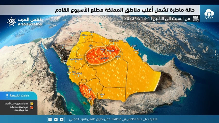
Saudi Arabia is on a date with weather disturbances that will bring thunderstorms to large areas of the Kingdom at the beginning of next week
From the "Arab Weather" center - specialists in the air operations department at the Arab Weather Regional Center for Meteorology and Weather Forecasts reported that large parts of the Arab East, including the Kingdom of Saudi Arabia, are on a date with a rainy situation early next week that includes large parts of it.
And in the details, the outputs of the computer processing developed in the Arab Weather Center indicate expectations of an eruption of a cold upper basin towards the eastern basin of the Mediterranean Sea and Egypt, to pump strong cooling in the upper layers towards the Arabian Peninsula in conjunction with the blowing of warm air currents from the south and the flow of moisture with characteristics Tropical towards the Kingdom, these weather conditions are expected to cause unstable weather conditions and thunderstorms in many western regions, starting from Saturday, and the rain range will expand on Sunday and Monday, God willing.

The effect of the rainy situation starts from southwestern Saudi Arabia on Saturday
And according to the latest indicators received by the weather forecast team in "Arab Weather", it is expected that quantities of cumulus clouds will multiply during the afternoon hours of Saturday 11-3-2023 in the southwestern regions represented by Najran, the heights of Jazan, Asir, Al-Baha and Makkah Al-Mukarramah, and These clouds are accompanied by medium to heavy rains, accompanied by occasional thunder and activity in surface winds, which leads to the flow of valleys and reefs in some areas.
And it is expected that with the evening and night hours, rain clouds will gradually extend to parts of Al-Madinah Al-Munawwarah, especially the southern parts of the region and the south and west of the Riyadh region administratively.
And with the hours after midnight (Saturday / Sunday night) and Sunday dawn, it is expected that the cold air mass will deepen in the upper layers of the atmosphere, so that the cumulus rain clouds gradually extend to the east and include various parts of the Riyadh region administratively, Qassim, Hail and Medina. It is also not excluded that some thunderclouds will reach separate parts of the coasts of Medina and Makkah Al-Mukarramah.
Sunday: The effect of the rainy situation will expand to include large parts of the Kingdom, God willing
And according to the future computer simulation of the movement of the depression, it is expected that the depression will gradually deepen in the upper atmosphere layers of the atmosphere of the Kingdom of Saudi Arabia on Sunday 3-12-2023 in conjunction with the influx of amounts of tropical moisture, so that the rains will begin, God willing, with regularity, intensification, and expansion. With more hail showers and severe thunderstorms sometimes, and rain includes on Sunday - God willing - large parts of the southwest and center of the Kingdom, including the heights and eastern parts of the regions of Asir, Al-Baha, Makkah Al-Mukarramah and Al-Madinah Al-Munawwarah, in addition to large parts From the administrative region of Riyadh (especially the northern parts of the region), Al-Qassim and Hail, and these rains are medium to heavy and are sometimes accompanied by thunder. It is also not excluded that some thunderclouds will extend in the same period to some northern regions.
And with the evening and night hours (Sunday night / Monday), it is expected, God willing, that the weather disturbances will intensify and concentrate at that time on different parts of the central region, including the Riyadh region, Qassim, and parts of Hail, and these rains will be medium to heavy and accompanied by the occurrence of thunderstorms And showers of hail, which leads to a rise in the water level in some areas. It is also expected that rain clouds will cover parts of the south of the Kingdom, including Najran, and parts of the eastern region, especially the northern parts of the region, in addition to some scattered areas of the northern borders and Al-Jawf.

Thunderstorms will focus on the eastern region on Monday and parts of Riyadh
And according to the analytical data in “Arab Weather”, it is expected that with the movement of the depression in the upper layers of the atmosphere to the east on Monday 13-3-2023, the weather disturbances will concentrate on the eastern region and parts of the Riyadh region administratively, and these rains will be mostly medium, and this It does not prevent it from being heavy at times, and at that time it is accompanied by the occurrence of thunder and showers of hail. At the same time, chances of thunderstorms are expected to continue in parts of Najran and the heights of Jizan and Asir, God willing.
Thunderstorms renewed on Tuesday and Wednesday!
And the computer outputs show those developed internally at the Arab Weather Center, that a new depression is expected to erupt in all layers of the atmosphere in the north of the Arabian Peninsula on Tuesday, March 14, 2023, which will lead to the proliferation of cumulus thunderclouds over parts of the northwest of the Kingdom in addition to parts of south of it. And this depression deepens into the Kingdom’s airspace on Wednesday, as rainy cumulus clouds spread again to several regions of the Kingdom.
And the "Arab Weather" center will inform you of more details during the coming days, God willing.
God knows.
Arabia Weather App
Download the app to receive weather notifications and more..


