Saudi Arabia | Rainy condition is considered the most extensive and extensive since the beginning of spring, which brings rain and dust to many regions
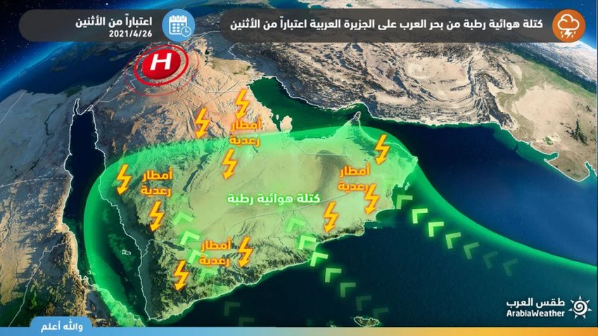
Arab Weather - Sinan Khalaf - is expected that the Kingdom will be affected by a rainy weather condition that is considered the best wide and most comprehensive in terms of the area of the affected areas, after the will of God since the beginning of this spring.
Heavy rain expected
Large parts of the Kingdom will be affected by the rainy situation
Despite the wide geographical area of the rainy situation and its comprehensiveness over large areas, the strength of thunder clouds and rain showers will focus on the western and southwestern highlands of the Kingdom, and by this we mean both the heights of Jizan, Asir Al-Baha and Taif, and expectations indicate that these areas will be vulnerable to heavy rainfall on a daily basis They are accompanied by heavy showers sometimes, with a high chance of torrential formation, especially in low-lying areas and mountain slopes.
The situation, however, is that the severity of the situation and its expansion, and the first air turbulence begins, God willing, on the night of Wednesday / Thursday, parts of the coasts and heights of the Tabuk region. The rains on Thursday are abundant over the highlands and coasts of Tabuk, with hail showers and surface wind activity during thunderstorms, while they are of moderate intensity sometimes in the rest of the regions with the possibility of water gatherings, while the rains are expected to reach the coasts of Yanbu on Thursday afternoon and evening, and the intensity is generally moderate.
Active to strong winds
Dust waves and downward winds are expected
This type of thunderstorm clouds at this time of year is often accompanied by the formation of descending air currents, which create dust waves and possibly local sandstorms in parts of the regions of Hail and Qassim and parts of the Riyadh region, which will reduce the extent of horizontal visibility and perhaps its absence,
The scientific reasons behind this air turbulence
This state of air turbulence comes as a result of the convergence of a hot air mass coming from the south with another lesser coming from the north, so that it creates a state of atmospheric instability, as a result of which clouds are formed and the opportunity is created for rain.


Arabia Weather App
Download the app to receive weather notifications and more..