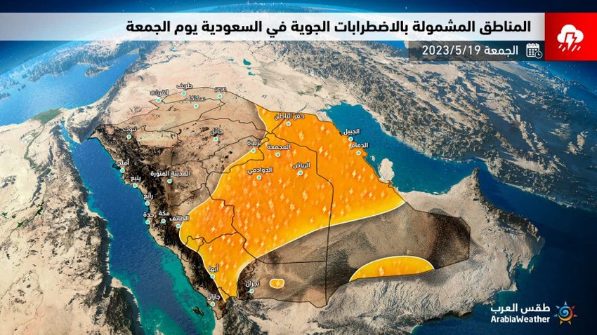
Saudi Arabia: Thunderstorms renewed in several regions of the Kingdom for the weekend
Weather of Arabia - The latest weather maps resulting from the so-called computer simulation indicate that the Kingdom of Saudi Arabia is expected to remain on Friday and Saturday 19 and 20 May 2023 under the influence of atmospheric disturbances associated with chances of thunderstorms accompanied by active winds that raise dust; This is due to the deepening of an atmospheric depression in the upper layers of the atmosphere that will remain for a short period near the region, coinciding with the rush of tropical moisture from the south.
And it is expected, God willing, that the cumulus clouds multiply again during the afternoon and evening of Friday over the heights of eastern Jizan, Asir and Al-Baha to the south and east of Makkah Al-Mukarramah, and it is accompanied by medium to heavy rains accompanied by the occurrence of thunderstorms and hail, which leads to Flow of valleys and reefs. Also, thunderclouds extend to large parts of the Riyadh region administratively, including the capital and the eastern region, and are accompanied by mostly moderate rains, but are interspersed with some heavy foci, as well as the downward winds that cause temporary dust storms. It is not excluded that some rain clouds condense in narrow bands, in general, from the regions of Qassim, Hail, Al-Jawf and the northern borders.

Chances of thunderstorms continue on Saturday on the southwestern heights represented by the heights of eastern Jizan, Asir, Al-Baha and eastern Makkah Al-Mukarramah, and they gradually extend to separate parts of Najran and the Riyadh region administratively, especially the southern governorates in addition to the eastern region and also focus on the southern parts of it. And the rains will be medium to heavy, accompanied by the occurrence of thunderstorms, hail, and activity in the downward winds that cause temporary dust storms.
It is noteworthy that these weather conditions that the Arabian Peninsula, including the Kingdom of Saudi Arabia, are exposed to are not usual for this time of the year, and they are represented by the flow and deepening of surface specific moisture into the region of the Arabian Peninsula (through the sea breeze cycle) if it is coming from the Arabian Gulf. Or from the Arabian Sea, which increases the chances of thunderstorms in several regions of the Kingdom of Saudi Arabia, amid complete weakness and cloudiness of the dry north winds, or what is called the Al-Bawareh winds ( more details on that ).
God knows.
Arabia Weather App
Download the app to receive weather notifications and more..


