Saudi Arabia: Updates and developments of the rainy situation and the areas covered by it in the coming days
Arab Weather - Weather forecasters at the Arab Weather Center reported that the rainy weather affecting the Kingdom for several days, which is characterized by its long self, is expected to renew at different periods during the current week, God willing. It is expected that the impact of the rainy condition on Monday will include new areas that will cause thunderstorms, which will be heavy in some parts, causing the risk of flash floods and floods. Provided that the impact of the rainy situation will continue at different times during the current week, God willing.
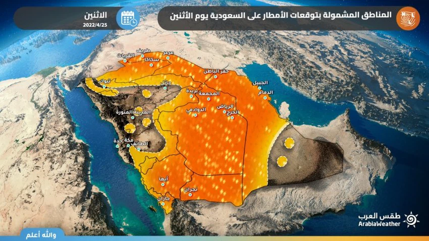
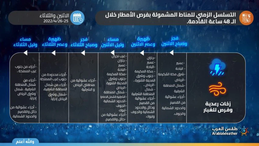
As indicated by the outputs of the computer modeling developed by Arab Weather , an expected deepening of the upper air depression in the Kingdom’s skies on Monday 25-4-2022 coincides with an effective response to the Red Sea depression and its expansion to central and eastern Saudi Arabia and neighboring countries, which means the proliferation of thunderstorms and their long rains. With varying intensity in many parts of the Kingdom, it is expected that thunderstorms will cover large parts of the southwestern sector of the Kingdom, including western Najran, Jazan, Asir, Al Baha and Makkah. It is not excluded that the chances of rain are the holy sites. Rain opportunities also include parts of the south and east of Medina, and large parts of the Riyadh region, including the capital, in addition to the eastern region, especially the northern sector of it, including Hafr Al-Batin and Dammam, and reaching many parts of the northern border, Al-Jawf, Tabuk, and to a lesser extent Al-Qassim and Hail, especially its north. .

According to the numerical outputs, it is expected that the rains will be heavy at times and cause the flow of valleys and the formation of torrents in a way that may be dangerous at times, in addition to being preceded in many cases by a great activity in the speed of the winds, which may cause the formation of local dust storms. There is a possibility that this time west of the Riyadh region will be exposed administratively to thunderclouds, which may be strong at times, in addition to parts of Al-Jawf and the northern borders. It is feared that flash floods and torrents will form in these areas in particular, in addition to the occurrence of almost a lack of horizontal visibility sometimes in the areas of thunderclouds effect. The resulting downward winds cause dust storms. It is not possible to know the places of development of cumulus clouds with severe turbulence specifically, but there will be a field follow-up of the meteorological situation firsthand to find out, God willing.
Thunder clouds activity moved to the east of the Kingdom more on Tuesday
According to the latest weather readings, indicators point to expectations that the upper air depression will move eastward to center in the northeast of the Arabian Peninsula, coinciding with a superficial extension of an air depression called the Red Sea depression, which leads to a new leakage of air currents saturated with tropical moisture, God willing. However, this time it seems that the weather disturbances will focus on the eastern sector of the Kingdom in the first place. So that the same atmospheric readings indicate expectations that the concentration of thunderstorms will shift over the eastern part of the Kingdom on Tuesday 26-4-202 to include several parts of the Sharqiah, including Hafr Al-Batin , Dammam , Jubail and Al- Nairiyah . The capital, Riyadh , rains on many periods, God willing. The rains are of varying intensity and are sometimes heavy, and cause the valleys to flow and form torrents in a way that may be dangerous at times, in addition to being preceded in many cases by a high wind speed that may cause the formation of local dust storms.
Despite the concentration of rain on the eastern sector of the Kingdom on Tuesday, cumulus clouds are forming along the southwestern heights of the Kingdom, represented by parts of Najran, Asir, Al Baha and Makkah Al-Mukarramah, and may extend to include the holy feelings again, and the rains are random in parts of Hail and Al-Qassim And the northern borders may extend in a limited and scattered way to some of the northwestern regions of the Kingdom.

According to the numerical simulation of the atmosphere, the rainy situation is expected to continue throughout the current week and even intensify again to include large parts of the Kingdom at the end of this week, including the capital Riyadh , in light of the control of systems of high atmospheric pressure over the central Mediterranean and western Asia, which leads To the retraction of the upper air depression towards the northeastern parts of the Arabian Peninsula, and an effective and clear surface response to the Red Sea depression, which leads to the excitation of tropical moisture and its rush in high values to the Kingdom, igniting the cumulus thunderclouds and increasing their density and thickness, thanks to God.
Based on the foregoing, there are a number of important recommendations that must be taken seriously regarding weather conditions, including:
- It is necessary to pay attention to the dangers of sudden torrential formation in valleys, reefs, low-lying areas and the usual water gathering areas.
- The need to pay attention to the same dangers, to stay away from valleys.
- Stabilizing external holdings due to the danger of strong downward winds that come temporarily and suddenly.
- Pay attention to the low horizontal visibility due to the possibility of dust associated with thunderclouds.
- Not to use electronic devices outside when there are cumulus thunderclouds, and to take shelter inside buildings when lightning strikes.
This and God knows
Arabia Weather App
Download the app to receive weather notifications and more..


