Scientific reading: Unusual paths of depressions in the Levant and the continued absence of the usual winter regimes
Weather of Arabia - The latest weather readings indicate that the Levant, including the Kingdom, is expected to be affected by unusual weather systems in terms of paths and impact during the first week of January, represented by unstable weather conditions that bring rain and whose impact is concentrated primarily on the southern and eastern regions and This means that these areas continue to be distinguished from others with much higher rates of rain for this time of the year, at the expense of the northern and central regions that live on a very weak rainfall until the moment, and God is the helper.
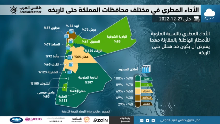
This is evident through the data of the Jordanian Meteorological Department, which shows that the rainy performance of the current rainy season and to date suffers from a significant shortage in the amounts of rain that are supposed to fall for this time of the year in most agricultural areas (including the northern Jordan Valley) and Areas in which dams are concentrated in Jordan (north and center of the Kingdom), for example, the Irbid station recorded 42 mm of rain since the beginning of the rainy season, with a performance of 30% compared to the assumed rate of 135 mm, as well as the case in Ajloun, which amounted to 57%. However, the matter is completely different, according to the results of the analysis of the same data, which indicate that the southern and eastern regions are witnessing a very special rainy season, thank God. In other words, what precipitated in Ma’an during the past weeks exceeds what precipitated in the same area over a period of more than five months (the seasonal average).

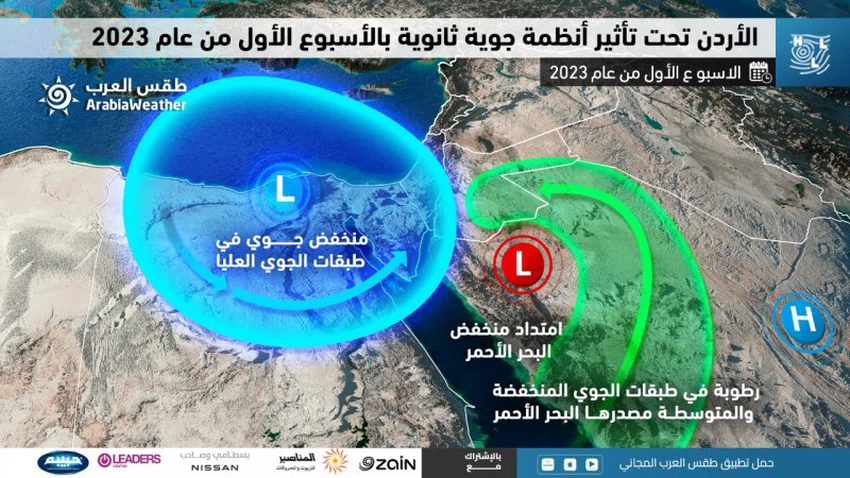
And the specialists of the Arab Weather Center said that this distribution of rain performance in various regions of the Kingdom and was distinguished in the Kingdom Valley only, due to the unusual behavior and paths of depressions in the upper layers of the atmosphere towards the region, sometimes through Iraqi lands and at other times taken north. The Egyptian lands are a path for it, and it is reinforced by the Red Sea thermal depression and the pumping of tropical moisture coming from the Arabian Sea through the Ethiopian plateau, which led to the emergence of unstable weather conditions that included large parts of the Kingdom of Saudi Arabia and other Gulf countries, while Jordan and Especially the southern and eastern parts of it, with secondary consequences of these cases during the past weeks, which is closer to the autumnal pattern than to the winter one.
Similarly, the outputs of computer simulations of the movement of air masses and systems indicate that a cold and moist air mass in the upper layers of the atmosphere is expected to descend towards the north of Egypt and move towards the east later during the week. Atmospheric instability affects southern Jordan with the hours of midnight on Sunday/Monday and during the day on Monday ( for more details ), and is renewed on Tuesday and Wednesday, accompanied by the chance of rain, God willing, in several regions of the Kingdom, concentrated in the east of the Kingdom, and it is not excluded That some of these showers are sometimes heavy and accompanied by the occurrence of thunder, and may lead to the formation of torrential rains in some areas.

That is, the system that affects Jordan is very intertwined and results from the convergence of the extension of the Red Sea depression and its coincidence with the presence of the cold air mass in the upper layers of the atmosphere in conjunction with the dominance of the eastern winds resulting from the Siberian air rise.
We ask God to grant us relief and not to make us despondent
Arabia Weather App
Download the app to receive weather notifications and more..


