Snow is approaching..and the strongest depression this season continues until Friday night
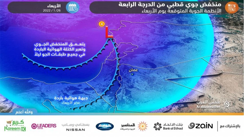
Arab weather - m. Nasser Haddad - Meanwhile, the polar air mass that hit Greece and Turkey is rushing south towards the eastern Mediterranean, and the strongest polar depression this season, classified as a fourth degree, is approaching the Kingdom on Wednesday, January 26, 2022.
Where it brings rain, God willing, to various regions, and it will be in the form of accumulated snow over areas whose height is more than 800-700 meters, and it is expected that the depression will continue at varying rates until Friday night.
Wednesday and Thursday.. different regions of the kingdom wear the white suit
It is expected, God willing, that intermittent showers of rain and hail will fall until two o’clock in the afternoon and will be over the high mountains mixed with snow, and then gradually cross a cold air front, so that the snow is regulating, especially in the late hours of the day and early evening over areas that are more than 800 meters high It is above sea level and it will be rain less than that, and it is not excluded that some accumulations will occur during the afternoon hours, especially over the high mountainous heights that include the heights of the capital Amman, to expand rapidly after sunset.

What is the fact that the snow coincides with the end of working hours for employees?
The actual beginning of the snow, including the capital Amman and the major cities of the Kingdom, will coincide with the end of the working period, especially with the period of Maghrib and the first evening (between four and six o’clock), where expectations indicate that snow will fall and accumulate on the roads, including the entire west of the capital Amman and parts of its east, And various areas that are more than 800 meters high.

Heavy snow awaits at night and snow reaches 700 meters.. Serious warnings of rapid snow accumulations!
As for the late night hours and after midnight, the Kingdom crosses a new polar air front loaded with large quantities and saturated with moisture in all air layers and crosses the depression and centers in northern Syria, so it is expected that the density of clouds will increase and become more powerful and lead to more cooling in the temperatures surface,
Therefore, snowfall becomes intense and extends to all heights above 700 meters above sea level in the north, central and east of the Kingdom and is accompanied by the occurrence of thunderstorms. Snowfall also extends to lower altitudes for some times, especially with the dawn hours. Heavy rain continues in low-lying areas.
In the south of the kingdom, the weather is very cold, stormy and often cloudy, with occasional snow showers over the mountains. Low-lying clouds touching the Earth's surface constantly cross mountainous regions, causing fog to form.
The winds are southwesterly to westerly, with strong speed, with strong gusts at times, especially over the southern high altitudes, with a speed exceeding 90 km/h.
Thursday and Friday | The depression is moving towards the east and the kingdom is gradually affected by polar and moist air currents rushing behind the depression :
Thursday morning until Thursday afternoon: Snow from time to time above the heights of more than 700 meters above sea level in the north and center of the Kingdom, with precipitation extending towards Karak Governorate and parts of Tafileh .
From Thursday afternoon until Friday/Saturday night : Formation of dense fog, precipitation and rain mixed with snow in the north and center of the Kingdom, in addition to the Karak Governorate. It is expected that snow will continue to fall at intervals over the high mountainous heights of more than 1000 meters above sea level, extending below that height at intervals .
Saturday | All kinds of direct effects of the polar system on the Kingdom end, and the weather stabilizes with the occurrence of freezing at night in most areas.
Arabia Weather App
Download the app to receive weather notifications and more..


