Strong effects of Storm Jana on the Iberian Peninsula and the Maghreb, and fears of torrents and floods in several regions
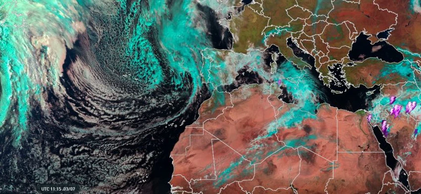
Arab Weather - The latest satellite images and remote sensing systems at the Arab Weather Regional Center monitor the development of a rainstorm over the waters of the northeastern Atlantic Ocean off the coast of Portugal (called Storm Jana), with very low atmospheric pressure values reaching 982 millibars, causing strong winds with an average of 100 km/h and gusts exceeding that, with the presence of dense bands of thick cumulonimbus clouds laden with large amounts of rain surrounding the center of the storm.
Storm affects Portugal and France (heavy rain and strong winds)
According to the latest outputs from the numerical models, and based on satellite image data, the storm is expected to strongly affect Portugal and Spain this evening and throughout tomorrow, Saturday, as large amounts of cumulus clouds will rush in and unstable weather conditions will prevail, leading to heavy to very heavy rains, which will be continuous in some areas, and accompanied by strong thunderstorms at times in several areas, including the capital Madrid, with heavy falling of hail of various sizes and sometimes large.
The storm is expected to cause a huge rainfall of 150-250 mm of rain, which means about 250 liters of water per square meter, causing torrents and floods and a significant rise in water levels on the roads, including the capital Madrid. Heavy snowfall is expected on the mountainous heights.
The effects of the storm reach the Maghreb, and heavy rains are expected in many regions, God willing.
The storm is expected to move south on Saturday and Sunday, and its direct impacts will begin on the Maghreb, where a complex state of atmospheric instability will form. As a result, thunderclouds will form and grow to high levels in the atmosphere.
This is accompanied by severe weather phenomena such as (heavy rain, thunderstorms, lightning, strong hailstorms with large hailstones, and strong downward winds). The terrain and topography of the land contribute to the process of lifting the air, especially the Atlas Mountains and neighboring areas. Mountain valleys and low-lying areas are susceptible to the sudden formation of torrential floods, in addition to the high risk of flooding in several areas due to the large amounts of rain expected in some areas.
God knows best.


Arabia Weather App
Download the app to receive weather notifications and more..