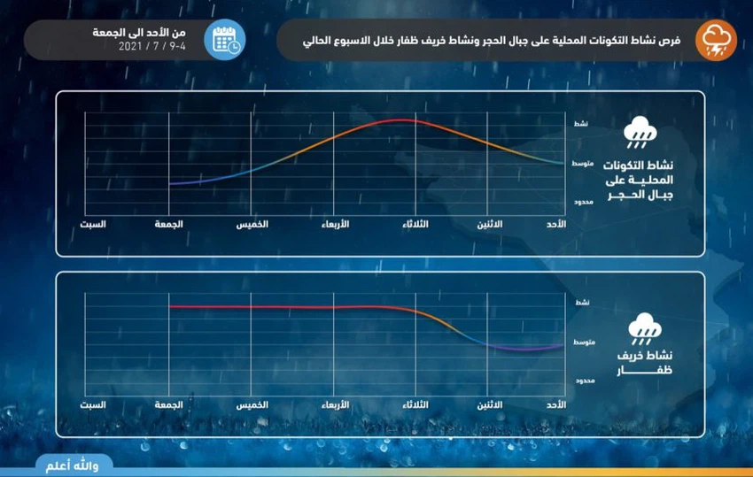
Sultanate of Oman | Arab Weather issues a chronology of rain forecasts on the Al Hajar Mountains and the fall of Dhofar and warns of the flow of valleys and reefs next week
Arab weather - The Sultanate of Oman is expected to be affected by a rainy situation from Sunday, including parts of the Hajar Mountains and the surrounding areas, and then expand during the middle of the week to become more severe to include parts of the coastal areas overlooking the Sea of Oman, and at the same time it is expected that the autumn will intensify. Dhofar gradually during the week.
Expected rain details تفاصيل
In the details, it is expected that unstable weather conditions will arise in the Sultanate from Sunday as the beginning of the rainy situation, before the rains intensify and the effect of thunder clouds expands during Monday and Tuesday, and it is expected that cumulus rainy clouds will cover most parts of the Hajar Mountains, especially the second and third belts, while Heavy rain will focus on Monday on the eastern and central stone, provided that the chances of the western stone will improve on Tuesday.

It is expected that rains will extend to neighboring areas from time to time and some desert and coastal areas, in addition to an increase in the intensity of rain on the coasts of Dhofar Governorate and the city of Salalah, and these rains are of varying intensity in general with their intensity at times, and are accompanied by an activity of surface winds that raise dust and dust in some areas, in addition to Major disturbance in the coastal areas bordering the Arabian Sea.
Arab Weather advises to pay attention to the dangers of sudden torrential rains when thunderstorms fall, especially in valleys and cliffs, and to pay attention to the risk of lightning and severe thunderstorms by taking shelter inside buildings, and finally a warning to sea-goers and navigation practitioners of the danger of going to the sea due to the wave height of more than four meters.
The reason for the formation of the rainy state is due to the flow of a tropical moist air mass, which raised the tropical separator towards the north, and the emergence of unstable weather conditions, coinciding with the concentration of the subtropical air high in the middle of Saudi lands, which causes the blowing of northwesterly currents that are an additional support for the expected situation.
What about temperatures?
When reviewing the temperatures for the next five days, it is expected that the temperatures will decrease during the coming days, as a result of the monsoon winds that cool the atmosphere, and normal and hot summer weather prevails of course and temperatures are below their normal rates, as the temperatures are around the beginning of the forties in most of the interior states. , While the weather is more moderate in the coastal areas and temperatures in the late twenties in the coastal areas overlooking the Arabian Sea, while it is hotter in the coastal areas adjacent to the Sea of Oman, while the temperature will rise again from Thursday.
Arabia Weather App
Download the app to receive weather notifications and more..


