Sultanate of Oman | Areas covered by chances of thunderstorms in the Sultanate on Monday 22-8-2022
Arab Weather - The maps processed in the "Arab Weather" center indicate expectations for the continuation of cumulus clouds activity on parts of the Hajar Mountains on Monday, coinciding with the activity of autumn clouds on the coasts of Dhofar Governorate, accompanied by occasional drizzle.
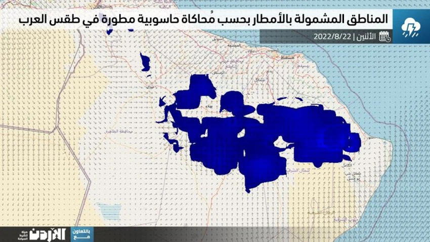
In the details, it is expected that cumulus clouds will renew during the afternoon and evening on parts of the Al Hajar Mountains, especially the eastern and central Al-Hajar Mountains, specifically those mountainous heights located in the governorates of North Al Sharqiah, Al Dakhiliyah, Al Dhahirah and Al Buraimi, so that the chances of cumulus clouds emerging are concentrated on the third belt of the Al Hajar Mountains. These clouds include rainfall of varying intensity, accompanied by the occurrence of thunderstorms and activity in downward winds, and it is not excluded that they may cause runoff in valleys and reefs in some areas.
This computer modeling developed in "Arab Weather" comes within the project to significantly improve the accuracy of forecasts by relying on special and intelligently developed equations that take into account the various models and terrain in order to reduce the error rate from the global models.
It is expected, God willing, to improve the activity of the Khareef Dhofar during the coming days, God willing, in conjunction with the approaching end of the summer vacation and the return of students to schools, for more details from here.
God knows.


Arabia Weather App
Download the app to receive weather notifications and more..