The Arabian Peninsula Gradually rainy weather events during the month include important cities and cold waves in the last third of it
Monthly weather forecast for the Arabian Peninsula
A cold start in some regions ... and the intensity and extent of rain improved in the second half of March, especially in the mawaweeh season
Note: It is strictly forbidden to transmit this information, data and the obligatory newsletter and publish it on social media and other means and / or dispose of it in any way without taking the prior and written consent of ArabiaWeather, under penalty of legal accountability .
General situation
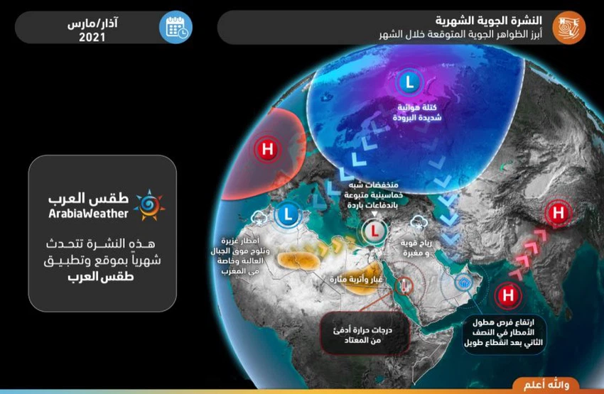
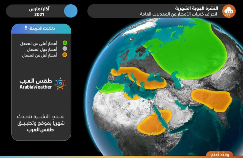
- The chances of rain improved and, God willing, instability in central and eastern Arabia formed in the second half of the month, especially the Maraweeh season.
- Increasing chances of rain in the capital, Riyadh, in the second half of March, God willing, and gradually.
- The end of the rainy depression in the Sultanate of Oman and the Emirates in the second half of the month, and the chances of scattered rains improved dramatically.
- Opportunities for rain focus on the western region of Saudi Arabia during the third week of the month, including parts of Medina.
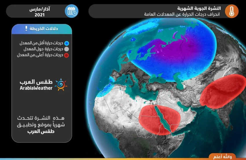
- Temperatures are significantly higher / warmer than normal levels in western Saudi Arabia and parts of Oman and the UAE during most of the month.
- A thermal contrast between warm and cold over northern and eastern Saudi Arabia and the Gulf countries.
- Continued chances of rain in Iraq and snow over high northern mountains at intervals during this month.
- Monitor the chances of dust waves forming across Egypt or locally in some periods of the month.
Aerial maps and infographics
The most prominent expected weather phenomena

Heat deviation / anomaly from general averages

Deviation / anomaly of rain from general averages

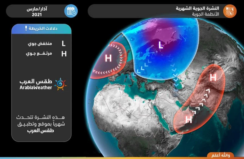
Important weather systems distribution

Detailed weather condition for every week
Week 1 (March 1-7)
Description of the week
Cold air basins dominate the Caspian Sea and western Russia, while the central Mediterranean regions, Pakistan and the southeastern Arabian Peninsula are affected by air heights.
This leads to stabilization of weather in the southeast of the Arabian Peninsula, while some upper depressions extend from the north and bring atmospheric instability to separate areas of the northern regions and parts of the southern region.
|
Region |
The rains |
the heat |
|
Central Saudi Arabia |
Light rain |
About rate |
|
Northern Saudi Arabia |
scattered showers |
Below average |
|
Southern Saudi Arabia |
scattered showers |
Above average |
|
Eastern Saudi Arabia |
Light rain, especially in the north |
Below average |
|
Western Saudi Arabia |
No significant rain |
Above average |
|
Iraq |
Medium rain showers and snow in the north |
Convert to higher than average |
|
Kuwait |
Rain showers |
About rate |
|
the two seas |
The possibility of light rain |
About rate |
|
Qatar |
There is no rain |
Convert to higher than average |
|
UAE |
There is no rain |
Above average |
|
Sultanate of Oman |
Showers |
Significantly higher than average |
|
To whom |
Medium rain and an opportunity for torrents to the west |
Convert to higher than average |
Week 2 (March 8-14)
Description of the week
It is expected that the atmospheric pressure will decrease and the effect of the tropical air height from the southeast of the Arabian Peninsula will diminish or weaken, thus allowing the extension of some cold upper air canyons from the north through Iraq and Iran,
This leads to the return of the chances of rain after a long absence in parts of the Sultanate of Oman, and parts of northern, central and eastern Arabia are affected by unstable weather conditions that result in the proliferation of clouds and precipitation, God willing.
|
Region |
The rains |
the heat |
|
Central Saudi Arabia |
Rain showers |
Above average |
|
Northern Saudi Arabia |
Thunderstorms |
About rate |
|
Southern Saudi Arabia |
scattered showers |
Above average |
|
Eastern Saudi Arabia |
Rain showers |
Below average |
|
Western Saudi Arabia |
Light rain |
Above average |
|
Iraq |
Medium rain, especially in the north, and snow in the north |
Convert to higher than average |
|
Kuwait |
Rain showers |
Above average |
|
the two seas |
scattered showers |
Convert to higher than average |
|
Qatar |
No significant rain |
Above average |
|
UAE |
Light rain to the east |
Above average |
|
Sultanate of Oman |
Rain showers |
Above average |
|
To whom |
Rain showers, especially in the west |
Above average |
Third week (15-21 March)
Description of the week
The tropical air height increases in the eastern and northern Arabian Peninsula, while some cold air masses are expected to extend towards the central and eastern Mediterranean.
This brings some rain, especially in the northwest and parts of central Saudi Arabia, with an opportunity to extend some rain from the western region for the first time (the best opportunity this month), especially in the east and south of the region, while more stable weather prevails in eastern Saudi Arabia, the Gulf countries, central and southern Iraq. Rains over the Sultanate of Oman and parts of the Emirates.
|
Region |
The rains |
the heat |
|
Central Saudi Arabia |
Rain showers and an opportunity for torrents |
Above average |
|
Northern Saudi Arabia |
Rain showers |
Above average |
|
Southern Saudi Arabia |
scattered showers |
Above average |
|
Eastern Saudi Arabia |
scattered showers |
Above average |
|
Western Saudi Arabia |
Rain showers |
Above average |
|
Iraq |
Rain in the east and north and snow in the north |
Above average |
|
Kuwait |
scattered showers |
Above average |
|
the two seas |
scattered showers |
Above average |
|
Qatar |
scattered showers |
Above average |
|
UAE |
Scattered rain in the east |
Above average |
|
Sultanate of Oman |
Rain showers |
Above average |
|
To whom |
Rain showers in the west |
Above average |
Fourth week and rest of the month (March 22-31)
Description of the week
Air heights are concentrated in the high air layers on northwestern Saudi Arabia and others over Pakistan, which paves the way from time to time for the extension of some upper air depressions towards the north, central and southeastern Arabian Peninsula.
Consequently, it is not a slave to continue the chances of rain, God willing, in several parts of the region, with reference to the improvement in the chances of rain also for the Emirates and the Sultanate of Oman.
|
Region |
The rains |
the heat |
|
Central Saudi Arabia |
Rain showers |
About rate |
|
Northern Saudi Arabia |
scattered showers |
About rate |
|
Southern Saudi Arabia |
scattered showers |
Above average |
|
Eastern Saudi Arabia |
Rain showers |
About rate |
|
Western Saudi Arabia |
Light rain |
Above average |
|
Iraq |
Rain showers |
Above average |
|
Kuwait |
scattered showers |
Above average |
|
the two seas |
Rain showers |
Above average |
|
Qatar |
Rain showers |
Above average |
|
UAE |
Rain showers |
Above average |
|
Sultanate of Oman |
Rain showers |
Above average |
|
To whom |
Showers are better in the west |
Above average |
Climate situation (for professionals and interested parties)
Arctic Dome and North Atlantic Ocean
It is expected that the month will start with large fluctuations in the behavior of the Arctic Oscillation Coefficient (AO) between a large decline to reach neutral and possibly slightly negative values during the middle of the first week of the month, to rise again at the end of the first week and the sea of the second week in a strong and possibly approaching +4, amid expectations that the pole will continue to be positive until the end of the month.
Pole positivity means / is related to the decrease in atmospheric pressure in the Arctic Circle extending from high latitudes between 60 and 90 north, and the coherence of the polar air affects and is related to the higher latitudes of the north of the globe, or what is known as the polar cell cohesion and a calm in the movement of polar jet currents .
Due to the relative weakness in the intensity of mid-showstorms, and the air pressure not deepening much in the Atlantic Ocean storms or in the European continent. Those sandwiched between latitudes 60 and 40 north .
It is expected that the North Atlantic Oscillation Coefficient (NAO) will rise and exit from the negative pattern gradually during the first week, to become positive after that until the end of the second third of the month, while expectations after that indicate that this indicator will decrease to approach the neutral and possibly negative pattern in Some days during the last third of the month.
The negativity of that factor is related to the bursting of very cold north polar winds and the outbreaks of air storms on parts of western Europe at some periods. While the positive factor of that coefficient indicates an increase in the atmospheric heights on the south and west of the European continent and the rush of warm and humid winds towards the north and west of the European continent .
This is related in the case of the weather in the Sub-Tropical Region , surrounding the Mediterranean basin, where it is close to the tropical region, where it is strongly influenced by the outcome / product of the polar cell in the north and the activity of the mid- width cell (Ferrell cell) . Expectations remained for the absence of strong extremes in values, and their fluctuation between slight negativity and moderate positive for both AO & NAO fluctuations.
As a result, it is expected that some breakages will occur in the wind movement in the upper atmosphere, or what is known as the refraction of jet streams, which leads to the push of cold air masses south towards the European continent, including parts of its east, God willing, especially in the second third of the month, and without It is unlikely that very humid winds will arrive from the Atlantic Ocean, supporting the hypothesis of a rainy depression around the middle of the month, due to the change in the behavior of the North Atlantic Ocean coefficient towards positive, which will push the construction of an air height on the southwest of the European continent and move it gradually eastward.
However, the severity of the high arctic oscillation coefficient will make it difficult for the prospective air system to transform into an integrated polarity in the central and eastern Mediterranean, due to the cold polar air being trapped in high shows in the north away from the Mediterranean basin, and thus the absence of a strong breakage in the currents. The polar jet towards subtropical regions (Mediterranean basin).
After that, that is, during the last third of the month, a change is expected in the distribution of weather systems in the northern hemisphere and the European continent, as cold air masses will take a path towards central and southwestern Europe due to a decline and decrease in the values of the Arctic and North Atlantic oscillation coefficients. Towards neutral values and one of them may enter a negative pattern, which results in high air pressure and the stability of the weather in the eastern Mediterranean at the expense of the return or intensification of air turbulence over the south and west of the European continent and the central and western Mediterranean. Rainy weather over the Levant during this period, due to the rapid and temporary fluctuation that may occur on the air systems.
Equatorial region of the Pacific Ocean
The equatorial region of the Pacific Ocean is witnessing a rise in temperatures while remaining below its general levels, and this is known as the (ENSO) index, as the phenomenon of lanina began to weaken and gradually shift to the neutral phase, and this phenomenon is statistically related to the Indian dipole index (IOD), where it is expected to actually start to rise. Slightly and gradually over the next two months (March and April and April 2021) .
Indian Ocean and Arabian Sea
The Arabian Peninsula is affected by the (IOD) index, and the positive of this indicator indicates that the surface water temperature from the western half of the Indian Ocean and the Arabian Sea is higher than the general rates, which indicates the increase in the quantities of moisture and water vapor in the air and its rush to the interior of the Arabian Peninsula and the improvement of the rain performance, God willing. The event of the eruption of cold air basins from the north and the formation of instability spring in character .
God knows
Arabia Weather App
Download the app to receive weather notifications and more..


