The heat dome ignites the atmosphere of North America... and the Vohn winds enhance the rise in temperatures
Arabia Weather - Weather forecasters at the Arabia Weather Center indicated that the latest computer modeling outputs indicate that large areas of the United States of America, especially its south and east, will continue to be affected by the heat dome phenomenon, which is accompanied by an air mass with high surface heating, such that very hot atmospheres prevail, especially with increased air heating due to The Fohn phenomenon, which we will explain at the end of the article.
The tropical high intensifies and fuels the heat dome over North America (temperatures exceed the mid-forties)
According to computer simulations, an overhead wave is expected to cross northern North America, leading to the tropical high intensifying southward, which will fuel the heat dome phenomenon, so that hot to very hot weather will prevail in various states, especially the southern ones. Daytime temperatures are expected to exceed the mid-forties Celsius in some areas, especially in Plain and low-lying areas below sea level.
What enhances the rise in temperatures and heating of the air is a climate phenomenon called “Fohn winds,” which will also have a clear role in the severity of the heat on the United States, especially in the plains, slopes, and valleys located east of the American mountain ranges.
Scientifically: The heat dome and the Foehn winds are two sides of the same coin and promote temperature rise side by side
A heat dome is a climate phenomenon that results from an area of high atmospheric pressure in the high layers of the atmosphere that heats the air in the lower layers of the atmosphere due to a dynamic process called (heating under pressure), whereby with the compression of the air in a certain area under the influence of an air high in the high layers of the atmosphere, a heat dome is created. A hot, surface air mass whose intensity varies according to the region and the intensity of the air high, and also according to the period of its formation during the year.
The air riser traps the hot air like a lid or cover on a boiling pot. As the hot air expands vertically in the atmosphere, the high pressure pushes it toward the ground again. The air is compressed again under the area of high atmospheric pressure, causing it to gain more heat. This is scientifically known as sub-heating. the pressure.
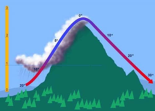
As for the Foehn phenomenon or Foehn winds, it is simply the decline of the wind from the high mountain peaks towards the slopes and low valleys, where rapid heating of the air occurs due to this movement of the air, as shown in the following figure.

As a quick mathematical operation in meteorology, the air cools by one degree Celsius whenever we rise 150 meters above sea level, but it warms by 1.5 degrees Celsius whenever we descend 150 meters above sea level. If we assume that we are in area (A) 00 meters above sea level and the air temperature 40 degrees Celsius, and there is a mountain 1000 meters high, and we want to know what the temperature of the same air would be if it moved from point (A) to point (B) behind the mountain, also at a height of 00 meters, then the process would be as follows: 40-(150/1000)* 1 + (150/1000)*1.5 = 43.34 degrees Celsius, meaning that the air temperature rose by 3.34 degrees Celsius at point (b) due to the process of descending the mountain.
God knows.
Arabia Weather App
Download the app to receive weather notifications and more..


