Typhoon Tao Tee is getting stronger in the Arabian Sea, and this is its likely path over the next 48 hours
Update: Sunday 5/16/2021 12:55 PM
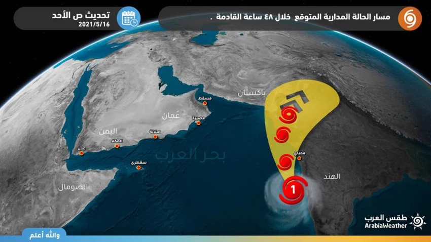
Weather of Arabia - Sinan Khalaf - The weather forecast staff at the Arab Weather Regional Center expected that the tropical cyclone Tau T, currently centered in the Arabian Sea, will move towards the Indian and Pakistani coasts away from the southern coasts of the Arabian Peninsula.
May develop into a Category 2 hurricane
The latest development of Hurricane Tao Te in the Arabian Sea
According to the latest meteorological observations, the typhoon Tao T is still classified as a first-class tropical cyclone, with a high probability of deepening and developing into the second degree on the cyclone scale, as it continues to move towards the north / northwest and then to the northeast towards the coasts of India and Pakistan, carrying huge quantities with it. From rain in addition to high winds.
Link to satellite monitoring of Hurricane Tao T in the Arabian Sea, from here
The latest weather observations of Typhoon Tao Te
- Tropical condition classification: Category 1 tropical cyclone
- Wind speed around the center: 65 - 75 knots
- Distance of the center from the coast of the Sultanate of Oman: 1560 km
- Associated clouds distance: 1220 km
- Expected trend of the case: North / Northwest
The Arab Weather website and application will follow up continuously and keep you updated on the latest developments of Cyclone Tao T in the Arabian Sea, moment by moment.


Arabia Weather App
Download the app to receive weather notifications and more..