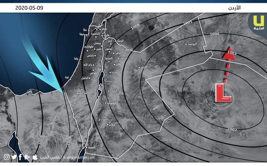
Under observation: Saturday's low develops and the chances of thunderstorms return
ArabiaWeather - The latest weather maps indicate that the expected depression on Saturday has evolved and is being monitored due to the significant change that has occurred in the weather maps during the past hours after it was weakly low in the initial readings. And the same maps indicate that a relatively cold air mass coming from Europe is expected to drive to the area to accompany the formation of an air depression centered on the Saturday afternoon in eastern Syria, and it will be classified within the next 24 hours.
It is expected that there will be a sharp and significant decrease in temperature and return again to become much less than what is used to for this time of the year on Saturday, and gradually increase the amounts of clouds and clouds at different altitudes and activate the wind speed remarkably and the weather turns To become relatively cold in general, and the opportunity to rain thunderstorms from the rain will come, God willing, especially in the north and central of the Kingdom, it may be heavy in narrow geographical ranges and be associated with falling showers from the cold, and the winds will be moderate to energetic speed with strong gifts, causing dust in South and east of the Kingdom and may cause waves of GBA Dense irrigation.
Saturday is recommended from:
- Attention from the danger of torrential rains and flow of wadis in narrow geographical areas in the northern and central regions of the Kingdom due to the heavy rains.
- Attention to the extreme wind speed, especially in the eastern regions.
- Attention to dense waves and their effect on high levels of dust in the air or causing them to significantly reduce the range of horizontal visibility.
These unstable weather conditions are preceded on Saturday by a significant and significant increase in temperatures on Friday as they become around their rates for such a time of the year, and the weather is warm and sunny by the will of God in most areas and tilted to heat in the afternoon and afternoon hours, while It is relatively hot to generally hot in the Jordan Valley, Bahr Al-Maleet and Gulf of Aqaba regions, and some clouds appear at different altitudes with the afternoon hours.
The winds will be southeasterly moderate, and will shift to northwesterly moderate winds, which will be active at intervals from afternoon hours. However, with the Friday-Saturday night hours, temperatures are generally high, and the weather is relatively warm in most regions, and sometimes dusty, especially in the eastern regions of the Kingdom.
The winds are northeasterly moderate, are active at intervals and are accompanied by strong gifts and possibly severe in the eastern regions, which leads to dust and possibly some dense waves sometimes.
God knows
Arabia Weather App
Download the app to receive weather notifications and more..


