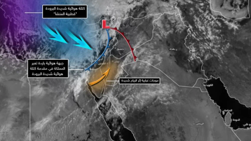
Update 4:30 pm - The latest developments in the depression, according to the latest satellite images
Weather of Arabia - Muhammad Aouina - The latest satellite images captured this afternoon, Tuesday 16-2-2021, indicate the positioning of the deep depression over the island of Cyprus with pressure values of 1001 millibars , and it is attached to a cold air front at the front of a very cold air mass of polar origin. Crossing the skies of the Kingdom during the next few hours, preceding the crossing of this prodigious front is a great increase in the speed of the surface winds, so that it is not excluded that the speed of some wind gusts reach 80 km / hour, as dust waves rush from the Egyptian lands and the Sinai desert towards the Kingdom, especially in the south and east of the Kingdom. .
According to the latest data received, the air depression is moving towards the east, and the cold air front is expected to cross in the early evening hours, so that a sharp drop in temperatures occurs and the opportunity for heavy thunderstorms of rain will start from the northern region, and then gradually towards the central and southern region, as well as intensify The speed of the winds becomes fierce, and towards the late night hours the opportunity is gradually created for snow showers over heights of more than 1000 meters, extending rapidly to heights of 900 meters and sometimes without.

While the rain falls during the Wednesday morning hours in the central and southern regions of Jordan, and the weather gradually turns to be dusty in different parts of the Kingdom, especially the southern regions, due to active southwesterly winds blowing with strong gusts of about 90-100 km / hour in particular. In the south of the Kingdom, it works to raise dense dust and sandstorms, and the rains are gradually renewed with the afternoon and evening hours , God willing, and are accompanied by lightning and sometimes thunder, and snow falls and accumulates over mountain heights of more than 750 meters, God willing.
It should be noted the importance of following up the issued reports to know the latest developments about the expected weather conditions.
ArabiaWeather Company shall not be responsible for any republication. The materials published in the “Arabia Weather Blogs” in the various media, which puts anyone who publishes these blogs in the name of the Arabia Weather or quoting the Arabia Weather under liability and legal accountability.
Arabia Weather App
Download the app to receive weather notifications and more..


