Urgent | A massive dust storm sweeps an Arab country and covers a quarter of its geographical area
Weather of Arabia - Sinan Khalaf - The downward winds associated with thunderstorms that affected Sudan yesterday, Tuesday, caused the emergence of a great dust storm in its strength and geographical area, as the latest satellite images show that the dust storm is currently covering an estimated quarter of Sudan's land area.
Seasonal rain with dust
Seasonal thunderstorms affect Sudan
At this time every year, Sudan is exposed to seasonal rains, during which thunderstorms are active, and they are often accompanied by currents of downward winds , which work on the emergence of dust storms of varying intensity in some neighborhoods.
How do downwinds arise?
Its speed can exceed 200 km/h
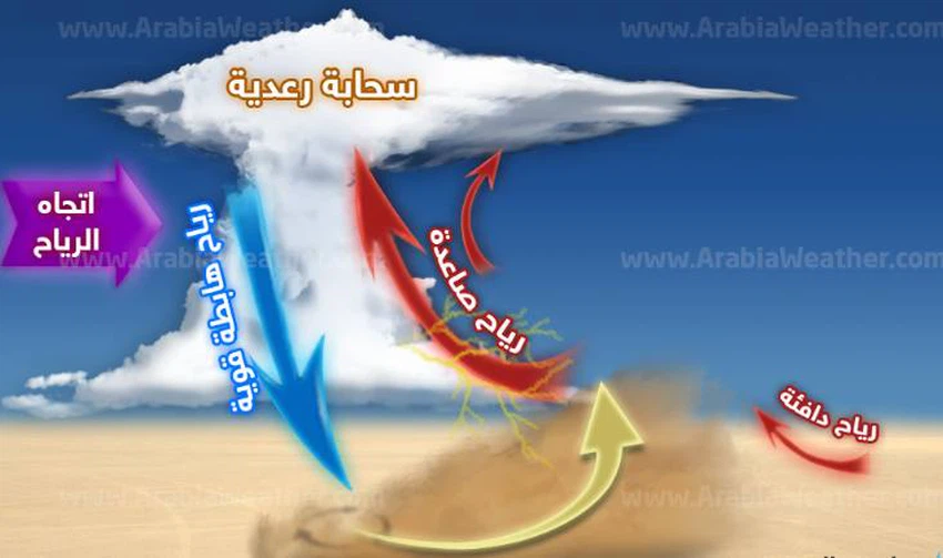
Such sandstorms are formed as a result of what is known climatically as “ downwinds ”, which are strong winds that fall from the cumulus cloud and strike the ground vertically, resulting in a dust wave that spreads in a circular motion and expands and takes the form of a huge, majestic brown cloud.
Follow the movement of the dust wave live from here

The downward wind arises due to the difference in the density of the air below the cumulus cloud. When it rains, the raindrops evaporate under the cumulus cloud before it reaches the ground, so the air in that part cools dramatically and becomes denser and heavier than the air around it, and it falls as a descending mass in the form of winds called “ the downward wind. ” And it hits the earth with a destructive force sometimes and at a speed that may exceed 200 km / h, which leads to the formation of dust waves whose density and strength vary according to the strength and intensity of the winds descending from the cumulus cloud.
Arabia Weather App
Download the app to receive weather notifications and more..


