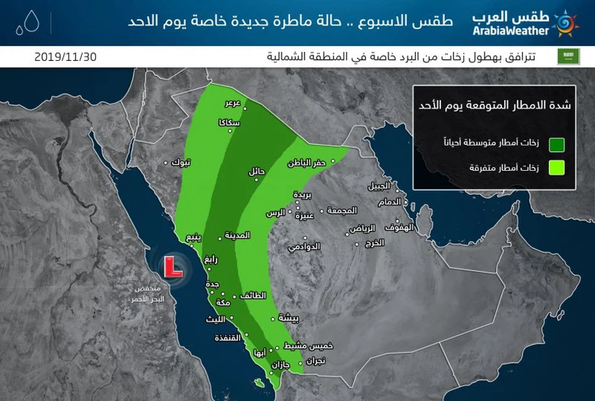
Weekly Weather Forecast A new rainy condition, especially on Sunday in western and northern Saudi Arabia
Arab Weather - Eng. NASSER HADDAD - Air turbulence in Saudi Arabia is renewed on Sunday and Monday, December 1 and 2, as it is expected to activate the Red Sea depression accompanied by rainy clouds of varying severity (light sporadic to medium intensity) on the southwest and west of the Kingdom and parts of its north, God willing.
Sunday. Rainy condition concentrated west and north of Saudi Arabia
With the hours of Sunday morning, the first rainy clouds begin to form after the will of God on some of the coasts of the Red Sea, especially the central and southern of them sporadically, sometimes accompanied by thunder.
Sunday afternoon and evening .. The breadth of rain clouds
During the afternoon and evening of Sunday , the thunder cloud extends, and the Red Sea low extends towards the north of the Kingdom, and thus includes parts of Mecca, Taif, Medina, Jawf, northern borders and Hail.With the evening and night hours, some thunderstorms extend towards Rafha and possibly Hafr Al-Batin.

In general, thunderstorms of varying intensity are expected between weak and sporadic to medium intensity, which may lead to some watersheds and possibly torrents in the highlands of the southwest of the Kingdom, as well as accompanied by showers of hail, especially east of Medina and north and west of the region of Hail and east of Jawf.
Monday .. The retreat of rain clouds and form a strong low air affects Iraq
As late night hours and dawn and Monday morning, the amount of rain drops from Saudi Arabia, due to the transformation of the Red Sea low to a closed low and move away from Iraq, where it brings heavy rains with the formation of floods and floods, especially in central Iraq.
On Monday, some sporadic rains on the eastern coast and showers of rain in the south-west of the kingdom, may God willing.
Weather in Riyadh
The weather is stable in the capital Riyadh for most of the week, with little chance of rain on Monday.
Temperatures this week
Temperatures are colder than normal in the northern region and parts of the north-east and north-west of the Kingdom, while the temperature is close to the average to warmer than normal in Riyadh and southwest of the Kingdom.
Arabia Weather App
Download the app to receive weather notifications and more..


