Seasonal Bulletin - Saudi Arabia | More intense and comprehensive rains include important cities during the second half of the marking
Arab Weather - Sinan Khalaf - As we enter the marking season, questions about the initial expectations of the season increase in terms of rain precipitation or in terms of temperatures and cold waves, and from this point of view, the Arab Weather teams issued the seasonal bulletin (months 11-12-1 .. November and December and January) for the year 2022 AD, accompanied by an explanatory video in addition to several aerial maps:
Gradual improvement in the extent and intensity of rain during the second half of the marking season to include important cities
weather charts:
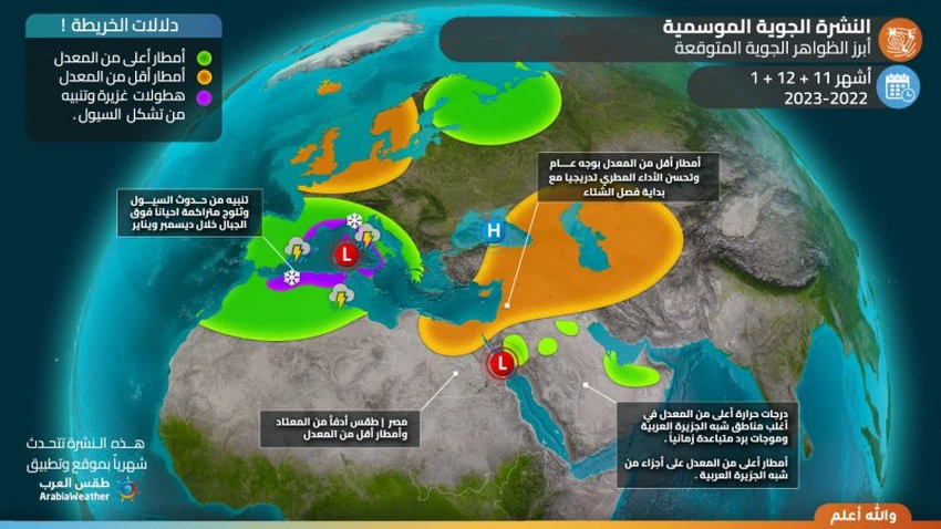
The most important weather phenomena expected

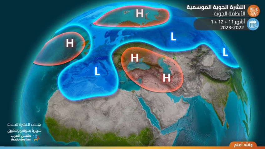
air systems

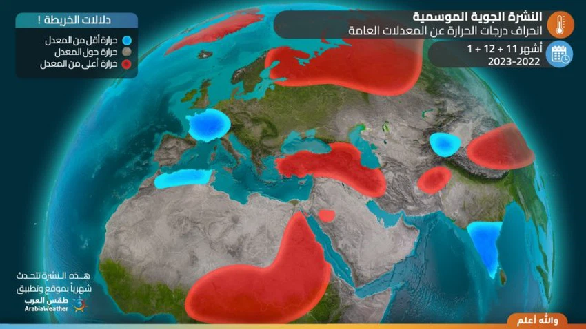
Temperature deviation from averages

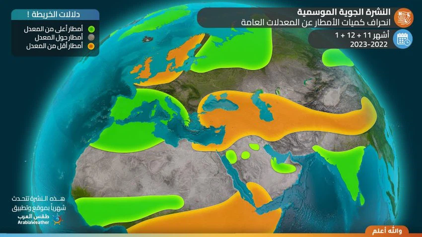
Deviation of rain from the general averages

General situation:
- After the second third of November, rains improved steadily over several parts of the Arabian Peninsula.
- Monitoring the possibility of several tropical states forming in the northern Indian Ocean (Arabian Sea and Bay of Bengal) during the second period of activity with its focus on the Bay of Bengal.
- Average temperatures in most parts of the Arabian Peninsula during the months of November, September and January.
- The beginning of cold waves and a noticeable decrease in the maximum and minimum temperatures alike over large parts of the Arabian Peninsula during the second half of November, but they will be far apart in time.
- The chances of reaching and deepening the cold upper basins of the Arabian Peninsula improved during the second half of November from the Levant and Egypt at times, and from the areas of Iraq and eastern Arabia at other times.
- Warning of high chances of dust/sand waves forming during December and January, as a result of the deepening of cold air masses from the northwest of the Kingdom and the huge thermal differences.
Weather for each month:
First month: November 2022
|
Region |
rain forecast |
temperature forecast |
Recommendations |
|
middle of Saudi Arabia |
Thunder rain |
underrate |
|
|
northern Saudi Arabia |
Thunder rain clouds |
Convert to above average |
Dust and dust raised and the water level in the roads high |
|
southern Saudi Arabia |
Thunder rain of varying intensity |
less than average |
The flow of valleys and reefs in some areas |
|
Eastern Saudi |
scattered thunder clouds |
about modifier |
Dust and dust raised and a warning of fog over parts of Al Sharqiya |
|
western Saudi Arabia |
Thunder rain of varying intensity |
underrate |
The flow of valleys and reefs in some areas |
- It is expected that the Kingdom of Saudi Arabia will be affected by air sub-systems in the form of extensions of rapid air depressions until mid-February, bringing with it rapid opportunities for frequent scattered rains.
- During the second half of the month, the center's specialists are optimistic about a positive change in the air systems, which leads to an improvement in the chances of reaching and deepening the cold upper basins of the Arabian Peninsula and the Kingdom of Saudi Arabia, in conjunction with the blowing of warm and humid air currents from subtropical widths, and a superficial response to the sea depression. The red is clearly and effectively, which leads to the emergence of unstable weather conditions and thunderstorms in several parts of the Kingdom of Saudi Arabia, especially the northern, north-central and western parts, God willing.
- Chances of the formation of tropical conditions remain in the northern Indian Ocean and the Arabian Sea during the month, God willing.
Second month: December 2022
|
Region |
rain forecast |
temperature forecast |
Recommendations |
|
middle of Saudi Arabia |
Scattered rain, sometimes thunder |
about average |
Warning of downward winds associated with thunderstorms |
|
northern Saudi Arabia |
Thunder rain of varying intensity |
About to above average |
Warning of high water levels on the roads and high chances of torrential rain |
|
southern Saudi Arabia |
Scattered showers, thundery and heavy at times |
underrate |
Alert from the flow of valleys |
|
Eastern Saudi |
Thunder clouds sometimes rainy |
about average |
|
|
western Saudi Arabia |
Scattered showers, thundery and heavy at times |
About to above average |
|
- A clear activity is expected for the central depressions on the European continent, in addition to a great activity in the strength of the Icelandic depression, so that the cold and rainy activity is concentrated on the central and western Mediterranean and northern Africa, and intensifies in the same period of the Siberian air high on parts of Russia and Central Asia, with its extension towards Iran and parts of northern Arabia at periods of the month.
- As a result, some cold upper air grooves sometimes extend from the north through Iraq and Iran, and at other times from the gateway to the Levant and Egypt, so that the opportunity arises because several parts of the Arabian Peninsula will be affected by unstable weather conditions that result in the multiplication of clouds and precipitation, God willing, with Keeping it within the usual framework in most regions.
- High chances of floods forming in some areas.
- An activity of surface winds that raises dust and dust in some areas, which reduces horizontal visibility.
- Chances of tropical conditions forming in the northern Indian Ocean remain during the first half of December with their focus on the Bay of Bengal.
Third month: January 2022
|
Region |
rain forecast |
temperature forecast |
Recommendations |
|
middle of Saudi Arabia |
Thunder clouds sometimes rainy |
about average |
Possibility of formation of water bodies |
|
northern Saudi Arabia |
Thunder rain of varying intensity |
underrate |
Possibility of water gatherings and rising water levels in the streets |
|
southern Saudi Arabia |
Scattered thunderstorms, sometimes heavy |
about modifier |
Flow of valleys and reefs |
|
Eastern Saudi |
Thunder rain of varying intensity |
underrate |
Possibility of formation of water bodies |
|
western Saudi Arabia |
Thunder rain of varying intensity |
about average |
The flow of valleys and reefs |
- It is expected that atmospheric systems will gradually change during this period, as the atmospheric pressure rises throughout the old continent, which leads to the rush of cold air towards the eastern basin of the Mediterranean, while it is expected that the subtropical air altitude will weaken from the north of the Arabian Peninsula, paving the way for improvement In the chances of the arrival of relatively cold air masses towards Egypt and northwest of the Arabian Peninsula.
- This leads to continued chances of rain at periods of the month on some parts of the Arabian Peninsula, especially the northern and eastern ones.
- An activity of surface winds that raises dust and dust in some areas, which reduces horizontal visibility.
The climate situation for those interested and specialists
The specialists at the Arab Weather Center monitor the expected behavior of the atmosphere during the next few months, which is directly affected by climatic factors that somehow reflect its circulation. Where the Arctic region is still witnessing an expansion in the extent of snow, the expansion of the snow cover in October over Siberia is statistically related to the weakening of the stratospheric polar vortex early in winter, and the control of atmospheric heights more than usual in many Arctic regions, which is the same This is felt by computer modeling of the simulation of the atmosphere.
There is no doubt that the Arab world is directly affected by the consequences of this, as it is expected that the distribution of air masses in the next two months (i.e. November and December) will be affected by the regions of the north and west of the European continent, all the way to the Maghreb countries in succession of cold and rainy depressions, which may It turns to snowy during the month of December, while the regions of the Levant and Egypt are affected by warmer air currents than usual on many occasions separated by the approach of air depressions that are mostly sub-systems, while parts of the Arabian Peninsula are expected to benefit from more mature weather systems During the second half of the marking season as a result of approaching cold grooves sometimes to the gate of the central Mediterranean and Egypt, and at other times to the eastern gate of the Arabian Peninsula.
Despite the high correlation coefficient in the aforementioned relationship, which usually means polar cold accumulation in the western European continent and sometimes eastern Canada to the eastern United States of America, the formulation of weather patterns is controlled by many complex factors, from the prevalence of the phenomenon of La Niña and Represented by the low surface temperatures of the waters of the tropical part of the Pacific Ocean, and the complex binary phenomena between water bodies and the atmosphere that undergo a sudden change sometimes during the season, which is scientifically called intraseasonal, such as the locations and intensity of the Madden and Julian waves (MJO). And whose effects vary from time to time according to other weather elements and indicators that are prevalent in the world.
And the specialists in the Arab Weather Center look with optimism at the beginning of next year, which is believed to bring with it drastic changes at the level of weather systems, which is represented by the control of air heights over important and wide areas of the west and central European continent, so that the eastern regions alternate at that time. And the middle of the Mediterranean Sea with cold air masses, and the regions of Iraq, the Levant, Egypt, northern Saudi Arabia, and perhaps parts of the Arabian Gulf were affected by more mature depressions.
As a general summary, it is expected that the autumn season will bring rains higher than the average in the countries of the Maghreb, which may be interspersed with snow on the highlands, while the regions of the eastern Mediterranean basin will be under the influence of sub-cases in general, but it is offset by a return to winter during the month of January , while it is believed that it will be the opposite in the Maghreb, where the atmosphere is more stable and warmer, God willing.
God knows.
Arabia Weather App
Download the app to receive weather notifications and more..


