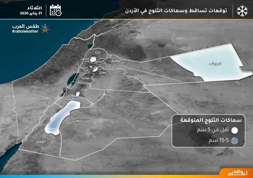
Infographic: Learn about snowfall and snowfall areas on Tuesday

2020-01-20 2020-01-20T17:26:30Z
وداد السعودي
وداد السعودي
محرر أخبار جوية- قسم التواصل الاجتماعي

Weather of Arabia - The Kingdom is affected from Monday morning until Wednesday morning, with an air depression classified as second degree according to the scale of severity of the depressions, accompanied by a very cold and arctic air mass that rushes to the region, specifically the Badia Al-Sham region. And the impact of this low air is associated with rain and snow, and remarkably low temperatures.


The following infographic shows areas of snowfall and their accumulation on Tuesday


This article was written originally in Arabic and is translated using a 3rd party automated service. ArabiaWeather is not responsible for any grammatical errors whatsoever.
See More
Related News
A huge polar air mass in eastern Europe: Why is it not expected to reach the Levant?

A huge polar air mass in eastern Europe: Why is it not expected to reach the Levant?

Jordan: Two low-pressure systems will affect the Kingdom. The first will begin on Saturday and is classified as a second-degree (normal) system, followed by another in the middle of next week.

Jordan: Two low-pressure systems will affect the Kingdom. The first will begin on Saturday and is classified as a second-degree (normal) system, followed by another in the middle of next week.

Heavy rain and snow are expected on the high mountains of several Arab countries this weekend.

Heavy rain and snow are expected on the high mountains of several Arab countries this weekend.

Jordan | Rain chances return starting Saturday, and this is what we expect for the end of the week

Jordan | Rain chances return starting Saturday, and this is what we expect for the end of the week