Analytical reading: The situation of the rainy season in Jordan is unusual and critical, and only 20% of it has been achieved, despite the end of the first half of the square
Arab Weather - The Arab Weather Center issued a new comprehensive report that highlights the monitoring of rainfall performance in Jordan, which suffers from severe and unprecedented weakness and the lack of arrival of integrated winter depressions despite the end of the first half of the winter square. This report addresses several aspects, including rainfall performance statistics, the scientific reasons behind this unusual weakness in rainfall performance, in addition to providing an initial vision of expectations in the coming period according to the latest information and analyzed data.
First: Evaluation of the reality and performance of the 2024/2025 rainy season so far
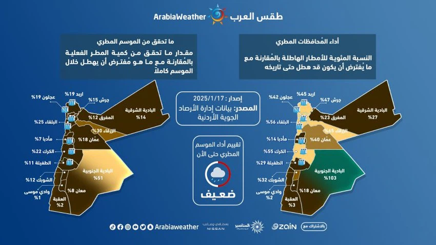
The Arab Weather Center studied the data of the Jordanian Meteorological Department for the current rainy season, updated until 1/15/2025, indicating that the rainy season is suffering from a significant and unprecedented shortage in the amounts of rain that are supposed to have fallen by this time of year in most regions of the Kingdom. The same data shows that most regions of the Kingdom have not come close to the expected rainfall total, and that all regions as a whole are suffering from a significant and unprecedented rainfall weakness in recent years, as the average performance of the rainy season did not exceed 50% compared to the amounts of rain that are supposed to have fallen by this time of year, while the percentage of what has been achieved from the entire rainy season so far has only reached about 20%, despite the middle of the square.
Experts at the Arab Weather Center indicated that the areas where dams are concentrated in Jordan suffer from a significant shortage of rain. For example, the rainfall performance in Irbid, Ajloun and Jerash reached around 45%, while in the capital it was 40%, while the rainfall performance decreased significantly in Aqaba, Ma'an, Tafilah, Shobak and all the southern regions, recording modest values ranging between 2 and 30%.
The experts at the Arab Weather Center considered, through this report, that these numbers and facts are very dangerous and must be taken very seriously by all sectors in the Kingdom, as they represent a very worrying water reality, in addition to a critical agricultural and animal reality. The report added that this climate event is an unusual climate event and has not occurred with this severity in years or even decades. The experts at the Arab Weather Center also noted that the region has not been exposed to integrated winter weather systems or depressions since the beginning of winter, and that the prevailing weather patterns are as if they are still in the fall.

Second: The scientific reasons behind the weak rainfall performance in Al-Mraba’aniyah (for those interested)
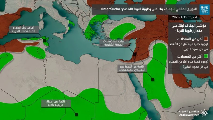
The report issued by the Arab Weather Regional Center in the Jordanian capital, Amman, stated that the main scientific reason for the weak rainfall performance in the Levant and Jordan until the date of issuance of this report (January 15, 2025) is the absence of integrated and mature winter depressions in the eastern basin of the Mediterranean Sea. This is due to the shape of the prevailing weather system in the northern hemisphere, which was represented by a clear imbalance in the Arctic system in the form of growing high air pressures in important areas of the pole, although it was not reflected as in previous years to the upper layers of the atmosphere (stratosphere), but it had a great impact on the behavior of the jet stream responsible for distributing weather patterns, so that it became weak and very wavy, which led to the polar air masses moving away from their original home towards large parts of the European continent and the eastern United States of America, and temperatures much colder than their averages prevailed in those areas. The report also noted that the behavior of the so-called polar vortex this winter is truly strange and unusual. Despite the strength of the stratospheric polar vortex, this was not reflected to the lower layers, and there was a separation between the two layers, which resulted in the atmosphere becoming more extreme and unusually turbulent.
The report added that this weather pattern (which can be called the polar vortex anomaly), which has been repeated frequently over the past years, may be due to many factors that are prevalent in the world at the same time and interact with each other to produce this weather pattern, such as the prevalence of the La Niña phenomenon, the locations and intensity of the Madden-Julian waves (MJO), and the interaction of that with the behavior and movement of the zonal winds in the stratosphere (QBO). There is no doubt that it produces extreme weather patterns of flooding in some areas and drought in others, and it has become clear how it affects the weather conditions in the Middle East, as the polar jet stream descended significantly towards the edges of the region and stimulated the subtropical jet stream, which led to the upper air depressions crossing atypically through the gateway of Egypt and northwestern Saudi Arabia instead of the surroundings of Cyprus and Crete, which produced a lack of normal weather events, at the expense of above-average rainfall in several parts of Saudi Arabia, especially since it coincided with the passage of the wet phase of the Madden and Julian waves. Globally, it should be noted that this pattern may be somewhat linked to the occurrence of the California fires as well. This can be explained by the concentration of deep air depressions towards the eastern United States, which was met by air highs in all layers of the atmosphere in the western United States, which led to drought in those areas (including California). In addition, these highs have a direct impact on the activity of what is known as the Santa Ana winds in California, which were one of the main causes of the fires ( read more about that via this link ).

Third: Expectations for the rest of January and a look at the coming weeks
The latest weather maps at the Arab Weather Center indicate that the weather is expected to remain stable and temperatures are warmer than their usual rates during the third week of January (until 1/22/2025), and later, during the last week and the rest of the current month, cold air is expected to approach the Kingdom, which may lead to the formation of air systems and depressions near the Levant region and the Kingdom, but it is not clear whether these air systems will be more mature than they were previously in this season.
Meanwhile, the weather forecasts reported in the quarterly bulletin for winter 2024/2025 issued by the Arab Weather Center earlier in December are still positive, indicating that the weather systems will witness an improvement during the month of February and an increase in the chances of winter depressions reaching the Kingdom compared to the current situation, especially since current indicators support that there is a significant and rapid recovery (which has already begun, but its effects need some time) in the polar vortex system and its return to the usual winter behavior, which may be reflected positively, God willing, on the region in the form of a return to the usual winter depression pattern. The forecasts for the coming months are available through the Arab Weather app
God is higher and more knowledgeable
We ask God to give us rain and not to make us among the despairing.
Arabia Weather App
Download the app to receive weather notifications and more..


